Unit 8: Africa
2/25 (Thu) or 2/26(Fri) Northern Africa
Jerusalem & 3 Monotheistic Faiths makeup
3/1 (Mon) or 3/2 (Tues) West Africa
Regional Conflicts makeup
3/3 (Wed) C Day makeup opportunities
3/4 (Thur) or 3/5 (Fri) Equatorial (Central) Africa
Arabian Peninsula makeup
3/8 (Mon) or 3/9 (Tues) East Africa
Northern, West, Equatorial, East Africa quiz
3/10 (Wed)
3/11 (Thur) or 3/12 (Fri) Southern Africa
end of 3rd 9 weeks grading period
3/15-3/19 Spring Break 2021
2/25 or 2/26 assignment
Northern Africa
read the sections below
you should be able to answer the questions at the end of this section
Northern Africa
read the sections below
you should be able to answer the questions at the end of this section

the mosques of Cairo, Egypt
|

The countries of North Africa
|

Marrakesh, Morocco
|
assignment for 2/25 or 2/26
Northern Africa
from https://www.newworldencyclopedia.org/entry/Northern_Africa
Northern Africa is generally accepted to refer to the northernmost region of the African
continent, stretching from the Atlantic shores of Morocco in the west to the Suez Canal and
the Red Sea in the east. By this definition, the nations included are: (1) Algeria, (2) Egypt,
(3) Libya,(4) Morocco, (5) Sudan,(6) Tunisia, and (7) Western Sahara

the Atlas Mountains
|

the Sahara Desert
|

the Nile River
|
The Land
from https://geography.name/north-africa-geography-and-population/
North Africa has three main geographic features: the Sahara, the Atlas Mountains in the west, and the Nile River and delta
in the east. The Atlas Mountains—a complex cluster of ranges, ridges, plateaus, and basins—stretch for 1,200 miles along
the North African coast from southwestern Morocco across Algeria to northeastern Tunisia. The tallest peaks are in the
High Atlas range in south-central Morocco, which has many snowcapped peaks.
South of the Atlas Mountains is the dry and largely barren expanse of the Sahara. In places the desert is cut by irregular
watercourses called wadis—streams that flow only after rainfalls but are usually dry. The Sahara's major landforms include ergs,
large seas of sand that sometimes form into huge dunes; the hammada, a level rocky plateau without soil or sand; and the reg, a
level plain of gravel or small stones. The Sahara covers the southern part of Morocco, Algeria, and Tunisia, and most of Libya.
Only two regions of Libya are outside the desert: Tripolitania in the northwest and Cyrenaica in the northeast.
Most of Egypt is also desert, except for the Nile River and the irrigated land along its banks. The Nile Valley is a narrow
green and fertile thread that runs the length of the country. The Egyptian desert also contains oases, fertile areas around
natural water sources. Oases are scattered through other parts of the desert as well.
|
|

|
Climate, Water and Resources
Coastal North Africa has a Mediterranean climate, with hot summers and mild, damp winters. Along the Atlas chain, the
mountains trap moisture-laden clouds blowing south from the Mediterranean Sea. The moisture falls as rain on the mountains'
northern slopes. As a result, these slopes and the coastal area between them and the sea are well-watered and fertile, compared
with the more arid conditions on the southern side of the mountains. Similar conditions exist in Libya, where cliffs and low
mountains separate Tripolitania and Cyrenaica from the desert interior.
Throughout North Africa, the availability of water has always been the chief factor in determining where and how people live.
In Egypt, 95 percent of the people live within a short distance of the Nile River or in the delta at its mouth on the Mediterranean Sea.
Water from the river is used to irrigate fields of cereal grains, vegetables, cotton, and other crops.
In the other North African countries, about 90 percent of the people live within 200 miles of the coast, generally in valleys
that have streams and rivers. These areas are suitable for agriculture, especially with the aid of irrigation. Citrus fruits, olives,
and grapes are major crops. Farther south, drier hills and grasslands bordering the desert have long been the home of pastoralists
who raise herds of sheep, goats, cattle, and camels. The only farming in the desert takes place in oases, where the main crops raised
are date palms, fruit, and cereal grains.
North Africa possesses valuable mineral resources. Libya and Algeria have extensive deposits of petroleum and natural gas.
Industrial development of these resources has been underway since the 1950s, and fuel exports are a major source of revenue
for these countries. Egypt and Tunisia have oil industries as well, though on a smaller scale. The region also contains small
quantities of other minerals, such as copper, zinc, and manganese. Morocco and Tunisia have fairly significant deposits of
phosphates, while iron ore is found in Algeria, Libya, and Tunisia.
Which nations are typically included in a list of Northern African countries? __(1)__
What is a wadi? __(2)__
What is an erg? __(3)__
What is a hammada? __(4)__
What is an oasis? __(5)__*
How does the availability of water impact Northern Africa? __(6)__
What crops are grown in Northern Africa? __(7)__
What mineral resources are found in Northern Africa? __(8)__
* Oases is the plural form of oasis
|
|
|
assignment for 3/1 or 3/2
West Africa

the Great Mosque at Djenne, Mali is made using adobe
|

the countries of West Africa
|

Lagos, Nigeria is the most populated city in Africa with a population of over 14 million; however, the Lagos metropolis (urban) area includes over 24 million residents
|
West Africa
from https://open.lib.umn.edu/worldgeography/chapter/7-3-west-africa/#:~:text=The%20region%20of%20West%20Africa,Desert%20and%20the%20Niger%20River.
The region of West Africa includes the southern portion of the bulge of the continent, which extends westward to the
Atlantic Ocean. This region is bisected by the African Transition Zone, which borders the southern edge of the Sahara Desert.
The main physical features include the Sahara Desert and the Niger River. The Cameroon Highlands are located on the
eastern border between Nigeria and Cameroon. At 4,100 miles long, the Nile River is the longest, while the Congo River is
Africa’s second longest at 2,922 miles in length. The Niger River is Africa’s third-longest river and extends more than
2,600 miles from the Guinea Highlands through Mali, Niger, and Nigeria before reaching the Atlantic Ocean in the Gulf of Guinea.
The African Transition Zone cuts across the region of West Africa, indicating a division between Islam and Christianity and
between the Sahara Desert and the tropics [sahel]. This diversity in religion and climate is usually exhibited with a
north/south division. Islam is the dominant religion on the north side of the African Transition Zone; Christianity is more
dominant to the south. The two religions often clash in the areas where they meet. Traditional beliefs and animist
religions are also practiced in the African Transition Zone.
What is Africa's 3rd longest river? __(9)__
Where does Africa's 3rd longest river begin __(10)__,
and into which body of water does it empty? __(11)__
Which religion is practiced by the majority of people living north of the
African Transition Zone __(12)__, and which religion is practiced south of the zone __(13)__?

|

|
The agricultural product shown above was harvested in Cote d'Ivoire where it is that country's largest export. What is it?
The Sahel
from https://www.britannica.com/place/Sahel
Sahel, Arabic Sāḥil, semiarid region of western and north-central Africa extending from Senegal eastward to Sudan. It forms
a transitional zone between the arid Sahara (desert) to the north and the belt of humid savannas to the south. The Sahel stretches
from the Atlantic Ocean eastward through northern Senegal, southern Mauritania, the great bend of the Niger River in Mali,
Burkina Faso (formerly Upper Volta), southern Niger, northeastern Nigeria, south-central Chad, and into Sudan.
The semiarid steppes of the Sahel have natural pasture, with low-growing grass and tall, herbaceous perennials. Other
forage for the region’s livestock (camel, pack ox, and grazing cattle and sheep) includes thorny shrubs and acacia and
baobab trees. The thorny scrub once formed a woodland, but the country is now more open and relatively traversable
by motor vehicle. The terrain is chiefly of the savanna type, with little continuous cover and a dangerous tendency to
merge into desert because of overstocking and over-farming. At least eight months of the year are dry, and rain,
confined to a short season, averages 4–8 inches (100–200 mm), mostly in June, July, and August. There are also
wide areas of pasturage watered by the flooding Niger and Senegal rivers. Modest crops of millet and
peanuts (groundnuts) can be raised in many areas.
The grass savannas of the Sahel can slowly become deserts. What actions performed by ranchers and
farmers can cause this to happen? ___(14)___
During which months does the Sahel receive most of it's annual rainfall? ___(15)___

Baobab Tree
|

the Sahara desert has been slowly moving southward into the Sahel
|

African savanna in the Sahel
|

semiarid areas of the Sahel
|
In the second half of the 20th century, the Sahel was increasingly afflicted by soil erosion and desertification resulting
from growing human populations that made more demands upon the land than previously. Town dwellers and farmers
stripped the tree and scrub cover to obtain firewood and grow crops, after which excessive numbers of livestock devoured
the remaining grass cover. Rainfall runoff and the wind then carried off the fertile top soils, leaving arid and barren wastelands.
The fragile nature of agriculture and pastoralism in the Sahel was strikingly demonstrated in the early 1970s, when a long period
of drought, beginning in 1968, led to the virtual extinction of the crops there and the loss of 50 to 70 percent of the cattle.
In 1972 there was practically no rain at all, and by 1973 sections of the Sahara had advanced southward up to 60 miles (100 km).
The loss of human life by starvation and disease was estimated in 1973 at 100,000. Severe drought and famine again afflicted
the Sahel in 1983–85, and desertification progressed despite some government reforestation programs. The Sahel continued
to expand southward into neighboring savannas, with the Sahara following in its wake.
Besides the extinction of crops, what was another economic disaster caused by the extended period of
drought from 1968 to 1970s? ___(16)___
click the buttons to find the geographic information needed to fill in the blanks below
Country Population in Millions Population Growth Literacy rate
Mali 19.6 M (2020 est) 2.95% ___(17)___
Sierra Leone 6.6 M (2020 est) 2.43% ___(18)___
Nigeria ___(19)___ 2.54% 59.6%
United States 335 M (2021) 0.7 % 99%
Mali 19.6 M (2020 est) 2.95% ___(17)___
Sierra Leone 6.6 M (2020 est) 2.43% ___(18)___
Nigeria ___(19)___ 2.54% 59.6%
United States 335 M (2021) 0.7 % 99%
|
|
|
assignment for 3/4 or 3/5
Equatorial (Central) Africa
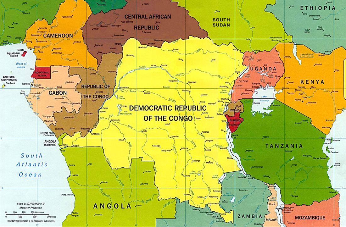
Equatorial (Central) Africa
Central Africa
from https://www.britannica.com/place/central-Africa
Central Africa [is a] region of Africa that straddles the Equator and is drained largely by the Congo River system.
It compromises, according to common definitions, the Republic of the Congo (Brazzaville), the Central African Republic, and
theDemocratic Republic of the Congo (Kinshasa); Gabon is usually included along with the Central African Republic because of
their common historical ties, both of these countries having once been part of French Equatorial Africa. Rwanda and Burundi,
although they are located east of the East Africa Rift System, which forms the eastern divide of the Congo basin, are also often
considered part of the region because of their long administrative connections with the former Belgian Congo (now Congo [Kinshasa]).
The island republic of São Tomé and Príncipe, off the Atlantic coast of Gabon, is also included in the region.
Which countries are located in Central Africa? ___(20)___

The city of Kinshasa in the Democratic Republic of the Congo is the largest French-speaking city in the world
|
Equatorial Africa refers to the countries of Africa that are on or near the equator
|
|
Which European governed the Democratic Republic of the Congo before it became an independent country? ___(21)__

the country of Gabon's product exports
|

the country of Uganda's product exports
|

the country of Central African Republic's products exports
|
What valuable commodity (product) is Gabon's largest export? ___(22)___
What agricultural commodity is Uganda's largest export? ___(23)___
What valuable commodity is the Central African Republic's largest export? ___(24)___
What agricultural commodity is Uganda's largest export? ___(23)___
What valuable commodity is the Central African Republic's largest export? ___(24)___
|
The Congo River
from https://rainforests.mongabay.com/congo/congo_river.html The Congo River -- formerly called the Zaire River -- is Africa's most powerful river and the second most voluminous river in the world with a discharge of 1,500,000 cubic feet of water per second. It is the second longest river in Africa after the Nile and ninth longest river in the world, draining a basin of nearly 4 million square kilometers (1.5 million square miles), or 13% of Africa's landmass. 
The Congo River provides hydroelectric power to the
Democratic Republic of the Congo |

the Congo River flows westward toward the Atlantic Ocean
|
The Congo River is the second longest river in Africa. Which river is first? ___(25)___
|
|
Rwanda Genocide
from https://www.history.com/topics/africa/rwandan-genocide During the Rwandan genocide of 1994, members of the Hutu ethnic majority in the east-central African nation of Rwanda murdered as many as 800,000 people, mostly of the Tutsi minority. Started by Hutu nationalists in the capital of Kigali, the genocide spread throughout the country with shocking speed and brutality, as ordinary citizens were incited by local officials and the Hutu Power government to take up arms against their neighbors. By the time the Tutsi-led Rwandese Patriotic Front gained control of the country through a military offensive in early July, hundreds of thousands of Rwandans were dead and 2 million refugees (mainly Hutus) fled Rwanda, exacerbating what had already become a full-blown humanitarian crisis. |
In the country of Rwanda, the ___(26)___ people are the largest ethnic group, while the ___(27)___ are the minority.
assignment for 3/8 or 3/9
East Africa
East Africa

Nairobi is the capital of the
country of Kenya |

The countries of East Africa
|

Mogadishu, the capital of Somalia, has been the site of terrorist attacks
|
Which countries are located in East Africa?___(28)___
Serengeti
from https://www.livescience.com/23310-serengeti.html
The Serengeti is a vast ecosystem in east-central Africa. It spans 12,000 square miles (30,000 square kilometers),
according to NASA, giving rise to its name, which is derived from the Maasai language and means "endless plains."
This region of Africa is located in north Tanzania and extends to southwestern Kenya. The Serengeti encompasses
Serengeti National Park and a number of protected game reserves and conservation areas maintained by the governments
of Tanzania and Kenya. The region hosts the largest mammal migration in the world and is a popular destination for African safaris.
Animals of the Serengeti
Blue wildebeests, gazelles, zebras and buffalos inhabit the region, along with lions and spotted hyenas familiar to
fans of the Disney film “The Lion King.”
Each year the great wildebeest migration begins in December in the Ngorongoro area of the southern Serengeti of Tanzania,
which offers rich grasslands for feeding. This is a huge attraction for tourists, and while many think it is an intense
and short-lived phenomenon, it is actually a fairly slow trek. It occurs during this time because there plenty of rain-ripened
grass available for the 750,000 zebra that precede 1.2 million wildebeest and then the hundreds of thousands of other plains
game bringing up the rear of the migration path.
What does the word Serengeti translated to in the Maasi language? ___(29)___
In which month does the wildebeest migration begin? ___(30)___
In which month does the wildebeest migration begin? ___(30)___

Herds of wildebeest and zebra migrate
in the Serengeti |

The Serengeti National Park is located in northern Tanzania and extends into Kenya
|

Spotted hyenas
|

Lake Victoria is Africa's largest lake
|
Lake Victoria
from https://www.newworldencyclopedia.org/entry/Lake_Victoria Lake Victoria or Victoria Nyanza (also known as Ukerewe and Nalubaale)is one of the Africa's Great Lakes. It is the continent's largest lake, the largest tropical lake in the world, and the second largest freshwater lake in the world in terms of surface area. But it is most well known as the source of the longest branch of the Nile River, the White Nile. Lake Victoria plays a vital role in supporting the millions of people living around its shores, in one of the most densely populated regions on earth. Unfortunately, the introduction of invasive species (the Nile perch and the water hyancinth) and pollution on a massive scale have had a harmful effect on the lake's ecology and biodiversity, as well as the amount of fish caught. In recent years, the water level of the lake has also been dropping, a trend attributed to regional drought and increased flows for hydroelectric power in Uganda. Which branch of the Nile River begins at Lake Victoria? ___(31)___
Besides drought, what is another cause of the water level dropping in lake Victoria? ___(32)___ |

Lucy
|

|
Lucy and the Leakeys
from https://www.khanacademy.org/humanities/big-history-project/early-humans/
how-ancestors-evolved/a/lucy-and-the-leakeys
Until the 1950s, European scientists believed that Homo sapiens evolved in Europe, or possibly in Asia, about 60,000 years ago.
Since then, excavation of fossil bones in East Africa, pioneered by Mary and Louis Leakey, has revealed that Homo sapiens
may have emerged in Africa much earlier.
Most scientists agree that the human species emerged somewhere in Africa about 200,000 years ago. This understanding
is based on fossilized bones and skulls that have been uncovered in East Africa and dated accurately by radiometric dating.
These bones and skulls range from 25,000 to 4.4 million years old and show many different stages of human and
primate evolution. These fossils have been uncovered by paleoarchaeologists — scientists who study the material
remains of the entire human evolutionary line.
Finding Lucy
Meanwhile, others had begun searching for fossil bones in Africa. After Louis Leakey died of a heart attack in 1972,
Mary Leakey continued working at Olduvai Gorge; however, the next spectacular find occurred in the Ethiopian
part of the Great Rift Valley, at Afar. In 1974, Donald Johanson, an archaeologist from Case Western Reserve University
in Cleveland, Ohio, found parts of a skeleton there that dated back 3.2 million years — the oldest hominine bones
yet discovered. Johanson nicknamed the skeleton “Lucy,” because that night, as he and the others in camp celebrated
their discovery, they listened repeatedly to the Beatles’ song “Lucy in the Sky with Diamonds.”
According to most scientists, where did the human species begin? ___(33)___
From where did "Lucy" get here name? ___(34)___
From where did "Lucy" get here name? ___(34)___
The use of Swahili was spread by Arab traders
|

Swahili is spoken in several East African countries
|
Swahili Language
from https://www.britannica.com/topic/Swahili-language
Swahili language,. . . [is a] Bantu language spoken either as a mother tongue or as a fluent second
language on the east coast of Africa in an area extending from Lamu Island, Kenya, in the north to
the southern border of Tanzania in the south.
People who speak Swahili as their sole mother tongue are usually referred to as Waswahili, but this name refers to their
language only and does not denote any particular ethnic or tribal unit. Swahili is widely used as a lingua franca* in:
(1) Tanzania, where it is the language of administration and primary education; (2) Kenya, where it is, after English, the
main language for these purposes; (3) Congo (Kinshasa), where a form of Swahili is one of the four languages of administration,
the main language for this purpose being French; and (4) Uganda, where the main language is again English.
Swahili has been greatly influenced by Arabic; there are an enormous number of Arabic loanwords in the language,
including the word swahili, from Arabic sawāḥilī (a plural adjectival form of an Arabic word meaning “of the coast”).
The language dates from the contacts of Arabian traders with the inhabitants of the east coast of Africa over many centuries.
Under Arab influence, Swahili originated as a lingua franca used by several closely related Bantu-speaking tribal groups.
In the early 19th century, the spread of Swahili inland received a great impetus from its being the language of the Arab
ivory and slave caravans, which penetrated as far north as Uganda and as far west as Congo. Swahili was later adopted
by European colonialists, especially the Germans, who used it extensively as the language of administration in Tanganyika,
thus laying the foundation for its adoption as a national language of independent Tanzania.
* lingua franca refers to a common language between people whose native languages are different
From which language did the name "swahili" originate? ___(35)___