Red Square in the Russian city of Moscow. The building on the right is St. Basil's Cathedral (built in 1561).
The building on the left is the Spassky Tower (built in 1491). The Spassky Tower is one of several towers
that guard the entrance to the Kremlin.
Unit 6: Russia, the Caucasus and Central Asia
January 5th to January 26th
1/5 (Tues B) or 1/6 (Wed A) European Russia
1/7 (Thur A) or 1/8 (Fri B) Siberia
1/11 (Mon A) or 1/12 (Tues B) Caucasus Region
1/13 (Wed)
1/14 (Thur A) or 1/15 (Fri B) begin new presentations asynchronous learning day
1/18 (Mon ) Martin Luther King Day
1/19 (Tues A) or 1/20 (Wed B) Black Sea and Caspian Sea 1st day of F2F teaching
1/21(Thur A) or 1/22 (Fri B) Central Asia
1/25(Mon A) or 1/26 (Tues B) presentations begin; Aral Sea

In area, Russia is the largest country in the world.
|
The Caucasus Region is named for the Caucasus Mountains. It lies between the Black Sea and the Caspian Sea
|

Central Asia stretches from the Caspian Sea to China. The Silk Road trade network passed through the region.
|
Russia
Russia Geographic Facts:
area 6.601 M sq. mi (1st) natural resources abundant timber and fresh water
population 145 M (9th) 2019 est. significant petroleum and natural gas reserves
ethnic groups Russians 80%, Tartars 3.9%, 1.4% Ukrainian much of Russia's land lies above 60 degrees North
federal republic (dictatorship) Vladimir Putin melting ice flows making Arctic ports useable
assignment for 1/5 or 1/6*
the assignment below is the makeup for European Russia
some of the answers to the blanks have changed
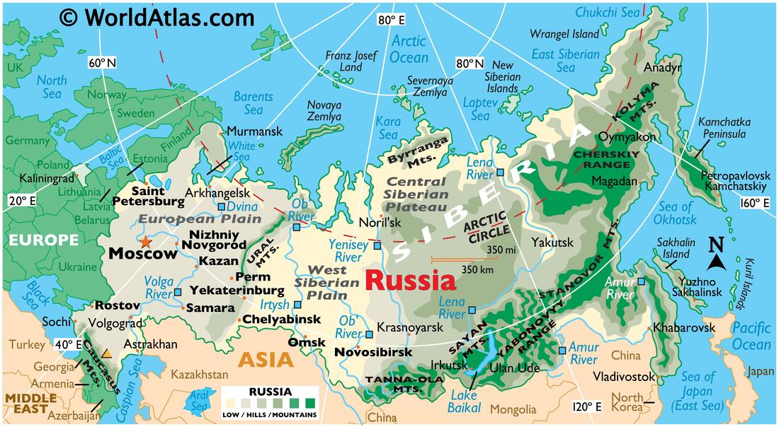
Use this map of Russia and to answer the questions below
Russia can be divided into 4 different geographic zones: European Plain,
West Siberian Plain, Central Siberian Plateau and the Russian Far East
European Plain
Russia's European Plain is bordered by the countries of Ukraine, Belarus, Latvia, Estonia and __(1)__,on its west;
the __(2)__ Mountains mark the Plain's eastern border. The __(3)__ Sea is located in the north
while the __(4)__ Mountains, the__(5)__ Sea and Caspian Sea are in the south. Two important rivers
which flow through the plain are the Volga River which empties into the __(6)__
and __(7)__ River which empties into the White Sea.
West Siberian Plain
The Ural Mountains are located on the West Siberian Plains' west border while the __(8)__ River
marks the eastern border. The __(9)__ Sea is located in the north while the Central Asian
country of __(10)__ is located along the plain's southern border. Besides the Yenisey, the Ob River and the __(11)__ River
flow through the West Siberian Plain. The region's largest city, __(12)__, is located on the Ob River.
Central Siberian Plateau
The Kara Sea and the __(13)__ Sea are found along the Central Siberian Plateau's north coast.
The East Asian countries of __(14)__ and Mongolia are located in the south. The Yenisey Rivers marks
the region's western border while the __(15)__ River is found marks the eastern edge.
Lake __(16)__, the deepest freshwater lake in the world, is located here.
Russian Far East
Russia's Far East region contains several mountain ranges.
The region's most important waterway, the Amur River,
begins in the Yabonovyy Range and flows until it empties into the __(17)__.
The largest city in the Russian Far East, __(18)__ is located on the Amur River

Moscow, Russia's largest city
|
|

St. Petersburg, Russia's 2nd largest city
|
|
|

|
|
use CIA:GOV World Factbook: Russia page to answer these questions
In 2017 Russia's exports were $ __(19)__ while the imports were $238 B (2017).
The exports-imports = a trade balance of $ __(20)__.
Russia's 2020 estimated population growth rate is __(21)__%.
The Three largest ethnicities are Russian 77.7%, __(22)__3.7% and Ukrainian 1.4%.
In Russia, the two most practiced religions are __(23)__ 15-20% and __(24)__ 10-15%.
__(25)__% of Russians live in cities (urban population)
__(26)__% of Russian can read and write.
assignment for 1/7 or 1/8
Siberia

map of Siberia
|

map of Trans-Siberian Railroad
|
the assignment below is the makeup for Siberia
some of the answers to the blanks have changed
some of the answers to the blanks have changed
Use the map of Siberia to fill in the blanks
The Ural Mountains divide the western border of Siberia from the Russian Plain. The city of Chelyabinsk is located at
the southern end of Russia's Ural Mountains. The city of __(1)__ lies directly north of Chelyabinsk.
The East Asian countries are located on Siberia's Southern border: __(2)__, Mongolia
and China. The Russian city of Vladivostok is located next to the Sea of __(3)__
The New Siberian Islands are located between the Laptev Sea and the __(4)___.
Use the Trans-Siberian Railroad map to fill in the blanks
If you traveled east from the city of Omsk on the Trans-Siberian Railroad the next city you will stop at is __(5)__.
The Trans-Mongolian Railroad begins at the city of Ulan-Ude and ends at the city of __(6)__.
The Trans-Manchurian Railroad connects the Chinese city of Shenyang, China to the city of __(7)__ , North Korea.

Siberian Village. Note swampy terrain from melting ice. Paved roads are rare because the extreme weather cracks the asphalt.
|
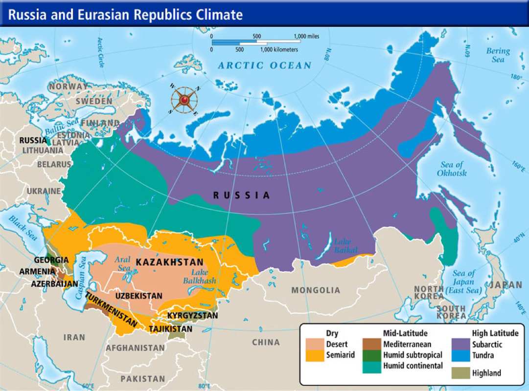
Climate map of Russia, Caucasus Region and Central Asia. Note the climates regions of Siberia.
|
Use the Russia and Eurasian Republics Climate map to fill in the blanks
While most of European (or Western) Russia has a __(8) __ climate, the largest climate zone in Siberia is __(9)__
The Aral Sea is locate within a __(10)__ climate zone, while the far northern parts of Russia that border the Arctic Sea experience a __(11)__.
While most of European (or Western) Russia has a __(8) __ climate, the largest climate zone in Siberia is __(9)__
The Aral Sea is locate within a __(10)__ climate zone, while the far northern parts of Russia that border the Arctic Sea experience a __(11)__.
|
video showing mosquitos swarms in Siberia
|
Australian video visiting coldest inhabited place on Earth
|
Read the article about Woolly Mammoths to fill in the blanks
Mammoth bones have been found in the muck (mud) of Lake __(12)__ in Siberia.
Mammoth went extinct __(13) ___ year ago. The Mammoth bones and the remains of other animals
were frozen for thousands of years in the Siberian ice, but rising temperatures and melting __(14)__ have
allowed scientists and illegal bone-collectors to find them
Read the article about Siberian Tigers to fill in the blanks
Amur Tigers are the largest subspecies of tigers in the world with males reaching __(15)__ feet long and
weighing 600 pounds. Amur tigers' large size gives them an advantage when hunting their favorite prey--big animals such as __(16)__, elk and roe deer. They are found in Eastern Russia, northeastern China and the north regions of __(17)__.
There were once eight subspecies of tigers. Today, three are extinct. Three others are __(18)__,
including the Amur Tiger.
assignment for 1/11 or 1/12
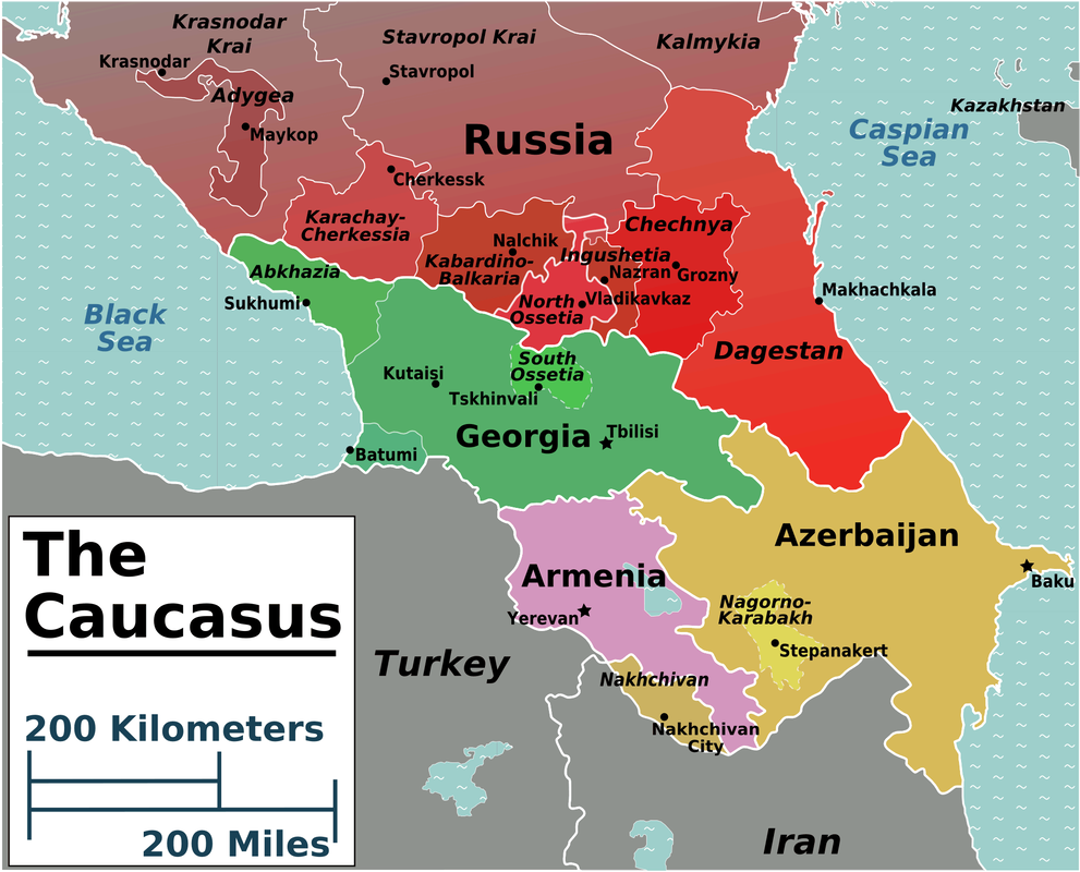
Caucasus Region
the assignment below is the makeup for Caucasus Region
some of the answers to the blanks have changed

Armenia, Azerbaijan and Georgia are called the "Caucasus Republics" because of their location near the Caucasus Mountains. Note the location of Nagorno-Karabakh
|
the causes of the 2020 Nagorno-Karabakh War between Armenia and Azerbaijan are explained in this video
|

Orthodox Monastery in Georgia
|

map showing the location of the Caucasus Mountains. Mount Elbrus is the highest mountain in Europe
|
use the Worldfact book to fill in the blanks
click "countries" at the top of the page
click one-page summary
click "countries" at the top of the page
click one-page summary
Type of Government
Armenia ____(1)____
Azerbaijan presidential republic
Georgia semi-presidential republic
Armenia ____(1)____
Azerbaijan presidential republic
Georgia semi-presidential republic
Geography
area(sq.km.) natural resources
Armenia __(2)__ gold, copper, molybdenum*,zinc, bauxite**
Azerbaijan 86.600 sq.km. petroleum, natural gas, iron ore, non-ferrous metal***, bauxite
Georgia 69,700 sq.km. ____(3)____
area(sq.km.) natural resources
Armenia __(2)__ gold, copper, molybdenum*,zinc, bauxite**
Azerbaijan 86.600 sq.km. petroleum, natural gas, iron ore, non-ferrous metal***, bauxite
Georgia 69,700 sq.km. ____(3)____
* molybdenum is a metal that can withstand very high heat; mixed with iron to make steel alloys
** bauxite is a type of rock with high concentration of aluminum
***non-ferrous metals are non-iron metals (copper, lead, zinc, tin)
** bauxite is a type of rock with high concentration of aluminum
***non-ferrous metals are non-iron metals (copper, lead, zinc, tin)
Economy
GDP per capita/PPP Exports minus Imports equals trade balance
Armenia $9,500 ('17) $2.63 B ('17) $ 3.77 B ('17) - $141 B ('17)
Azerbaijan ____(4)____ $15.15 B ('17) ___(5)___ ____(6)____ Georgia $10.700 ('17) $3.56 B ('17) $7.42 B ('17) -$3.86 B ('17)
GDP per capita/PPP Exports minus Imports equals trade balance
Armenia $9,500 ('17) $2.63 B ('17) $ 3.77 B ('17) - $141 B ('17)
Azerbaijan ____(4)____ $15.15 B ('17) ___(5)___ ____(6)____ Georgia $10.700 ('17) $3.56 B ('17) $7.42 B ('17) -$3.86 B ('17)
People & Society
Pop. Pop. Grwth Ethnicities w/% religion w/%
Armenia 3.02 M ('20) ____(7)____ Armenian 98.1% Armenian Apostolic 92.6%
Azerbaijan 10.3 M ('20) ____(8)____ Azerbaijani 91.6% ____(9)____
Georgia 4 M ('20) .05%('20) Georgian 86.8% Orthodox 83.4%
Pop. Pop. Grwth Ethnicities w/% religion w/%
Armenia 3.02 M ('20) ____(7)____ Armenian 98.1% Armenian Apostolic 92.6%
Azerbaijan 10.3 M ('20) ____(8)____ Azerbaijani 91.6% ____(9)____
Georgia 4 M ('20) .05%('20) Georgian 86.8% Orthodox 83.4%
|
Beginning in 1915, the Young Turks* began to arrest ___(10)___ living in the Ottoman Empire**. The Turks hanged many of the Armenians in the streets of __(11)__, before beginning the __(12)__ of most of the Armenian population to the desert, in which up to a __(13)__ died or were murdered . . .
*the Young Turks were young Turkish men who wanted to end the corruption in the Ottoman Empire
**In 1923 the Ottoman Empire was renamed Turkey |
__(14)__ is the capital city of Armenia with over 1 million residents
|
|
In 2008, the country of Russia and the much smaller country of ___(15)___ fought a brief war for control of two territories that Georgia claimed. The territories of Abkhazia and ___(16)___ made up __(17)__% of Georgia's total land. When the Georgian army invaded South Ossetia they were defeated. The war lasted __(18)__ days. The Russo-Georgian War displaced an estimated __(19)__ people, many of whom fled __(20)__ of Georgians in the separatist territories.
|
|
You must research this answer on your own
Mount Ararat is located near the border of Turkey, which is a Muslim country, and Armenia, which is a Christian country. Both countries view the mountain as sacred. According to the Bible and the Koran, what event happened at Mount Ararat? ___(21)___
Mount Ararat is located near the border of Turkey, which is a Muslim country, and Armenia, which is a Christian country. Both countries view the mountain as sacred. According to the Bible and the Koran, what event happened at Mount Ararat? ___(21)___
assignment for 1/14 or 1/15*
new presentation assignments
*this is an asynchronous day
the presentations begin on 1/25 or 1/26
the presentations will be scored as a mastery grade
assignment for 1/19 or 1/20
Black Sea and Caspian Sea
This is the makeup for Black Sea and Caspian Sea
Some of the answers have changed from the original assignment

map of the Black Sea
|

map of the Caspian Sea
|
use Wikipedia to fill in the blanks
total surface area (in sq. miles) bordering countries
Black Sea 168,500 Turkey, ___(1)___, Romania, Ukraine, Russia, Georgia
Caspian Sea ___(2)___ Iran, Azerbaijan, Russia, ___(3)___, Turkmenistan
total surface area (in sq. miles) bordering countries
Black Sea 168,500 Turkey, ___(1)___, Romania, Ukraine, Russia, Georgia
Caspian Sea ___(2)___ Iran, Azerbaijan, Russia, ___(3)___, Turkmenistan
click the 7 Seas button above and read the Library of Congress (LOC) article about the history of the term "7 Seas"
Most current sources state that “seven seas” referred to the Indian Ocean, Black Sea, Caspian Sea, Adriatic Sea,
Persian Gulf, Mediterranean Sea, and the ___(4)___.
Today we recognize more than 50 seas worldwide. A sea is defined as a division of the ocean which
is enclosed or partially enclosed by land. With that said, the Caspian Sea, ___(5)__, and Aral Sea are actually ___(6)___,
because they lack an outlet to the ocean.

this map shows the flow of the Mediterranean Sea
into the Black Sea |

Istanbul, Turkey
|
|
click the Black Sea button above and read the New World Encyclopedia article about the history of the term Black Sea
The Black Sea is an inland sea between southeastern Europe and the Anatolian Peninsula (Turkey) and is ultimately connected to the Atlantic Ocean via the Mediterranean and ___(7)___ Seas and various straits. The Bosporus Strait connects it to the Sea of Marmara, and the long, island-bound strait of the Dardanelles connects it to the ___(8)___ region of the Mediterranean. These waters separate eastern Europe and western Asia. To its east, the Kerch Strait links the Sea to the smaller Sea of Azov. The most important river entering the Black Sea is the ___(9)___. |
|

A warm day in Sochi. The city has a subtropical climate
|
click the Black Sea button above and read the CNN article about the weather at the 2014 Winter Olympics
Most people think of Russia in winter and picture the snow-covered cathedrals of ___(10)___, where average temperatures in February range between minus 10 Celsius (14 Fahrenheit) and minus 4 C (24.8 F) and all but require the wearing of those iconic fur hats. Sochi, however, is one of the ___(11)___ cities in Russia. It’s located over 1,000 km south of Moscow and has a completely different climate. Indeed, on most winter days, Sochi (and the nearby town of Adler, where many of the events are being held) are the warmest locations in the country. This was the case on Monday [February 10th 2014], when Sochi reached a balmy 15.9 C (61 F) – warmer than any other Russian city by more than 1 C. The ___(12)___ cannot say Sochi’s temperatures this month come as a surprise, as the city has the warmest climate of any Winter Games host city. |
click the Caspian Sea button above and read the Encyclopedia Britannica article about the history of the Caspian Sea
The Caspian is the largest salt lake in the world, but that has not always been true. Scientific studies have shown that until relatively recent geologic times, approximately ___(13)___ years ago, it was linked, via the Sea of Azov, the ___(14)___, and the Mediterranean Sea to the world ocean. The Caspian is of exceptional scientific interest, because its history—particularly former fluctuations in both area and depth—offers clues to the complex geologic and climatic evolution of the region. Human-made changes, notably those resulting from the construction of dams, reservoirs, and canals on the immense ___(15)___ system (which drains into the Caspian from the north), have affected the contemporary hydrologic balance. Caspian shipping and fisheries play an important role in the region’s economy, as does the production of petroleum and ___(16)___ in the Caspian basin. The sea’s splendid sandy beaches also serve as health and recreation resorts.
The Caspian is the largest salt lake in the world, but that has not always been true. Scientific studies have shown that until relatively recent geologic times, approximately ___(13)___ years ago, it was linked, via the Sea of Azov, the ___(14)___, and the Mediterranean Sea to the world ocean. The Caspian is of exceptional scientific interest, because its history—particularly former fluctuations in both area and depth—offers clues to the complex geologic and climatic evolution of the region. Human-made changes, notably those resulting from the construction of dams, reservoirs, and canals on the immense ___(15)___ system (which drains into the Caspian from the north), have affected the contemporary hydrologic balance. Caspian shipping and fisheries play an important role in the region’s economy, as does the production of petroleum and ___(16)___ in the Caspian basin. The sea’s splendid sandy beaches also serve as health and recreation resorts.

|
click the button titled, Beluga Caviar
and then fill in the blanks below About Beluga Caviar Beluga caviar is by far the most highly prized and expensive of all the caviar varieties. Originating in the ___(17)___, the beluga sturgeon (Huso Huso) lays the largest and softest roe of any sturgeon. These glorious shining eggs, ranging in color from light gray to black, are considered a luxury commodity, with a price often somewhere between $5000 and $10,000 per kilogram. Caviar connoisseurs consider eating beluga caviar one of life’s greatest pleasures . . . Okay, so it’s delicious. But lots of things are delicious. So why has beluga caviar specifically become such a prized and expensive food? The answer lies in the fish itself. The beluga sturgeon is huge, in rare cases even weighing more than 2000lbs and growing over 20 feet in length! It can also live for over ___(18)___. Consequently, the female beluga sturgeon has a very long maturation cycle, taking around 25 years before she’s ready to lay eggs. This means that a caviar farmer has to invest huge amounts of time, money and resources feeding and raising a beluga sturgeon before recouping his or her investment. |
assignment for 1/21 or 1/22
Central Asia

Nur-Sultan, capital city of Kazakhstan
|

Rudaki Park in Tajikistan's capital city, Dushanbe is dedicated to the Islamic poet Abu 'Abd Allāh Ja'far ibn Muḥammad al-Rūdhakī
|

Olympic Stadium in Ashgabat, Turkmenistan. Note the "horse-head"
tower on the left |

|
Central Asia, central region of Asia, extending from the Caspian sea in the west to the border of western China in the east. It is bounded on the north by Russia and on the south by Iran , Afghanistan, and China. The region consists of the former Soviet republics of Kazakhstan, Uzbekistan, Tajikistan, Kyrgyzstan, and Turkmenistan.
Central Asia’s landscape can be divided into the vast grassy steppes of Kazakhstan in the north and the Aral Sea drainage basin in the south. About 60 percent of the region consists of desert land, the principal deserts being the Kara-Kum, occupying most of Turkmenistan, and the Kyzyl-Kum, covering much of western Uzbekistan. Most of the desert areas are unsuitable for agricultural use except along the margins of the Amu Darya and Syr Darya river systems, which wind their way northwestward through Kyrgyzstan, Tajikistan, and eastern Uzbekistan and Turkmenistan after rising in mountain ranges to the south and east. |
from https://www.britannica.com/place/Central-Asia (map and text above)
the assignment below is the makeup for Central Asia
some of the answers to the blanks have changed
click the Kazahkstan button above and use the CIA.GOV summary to fill in the blanks below
The capital city of Kazakhstan is Nur Sultan. The three most important natural resources found in Kazakhstan are ___(1)___, natural gas and coal. In 2017, the value of exports was $49.29 B, while the cost of imports was $31.85 B. In 2017 the trade balance was $17.44 B.* The estimated population for 2020 is ___(2)___. The largest ethnic group in the country are Kazakhs, while the largest religion is ___(3)___.
The capital city of Kazakhstan is Nur Sultan. The three most important natural resources found in Kazakhstan are ___(1)___, natural gas and coal. In 2017, the value of exports was $49.29 B, while the cost of imports was $31.85 B. In 2017 the trade balance was $17.44 B.* The estimated population for 2020 is ___(2)___. The largest ethnic group in the country are Kazakhs, while the largest religion is ___(3)___.
*Exports - Imports= Trade Balance
|
|

export tree map for Kazakhstan (2012)
|

export tree map for Turkmenistan (2012)
|
click the Turkmenistan button above and use the CIA.GOV summary to fill in the blanks below
The capital city of Turkmenistan is ___(4)___. The four most important natural resources found in Turkmenistan are petroleum, natural gas, sulfur and salt. In 2017, the value of exports was $7.458 B, while the cost of imports was $4.571 B. In 2017 the trade balance was $2.887 B. The estimated population for 2020 is ___(5)___. The largest ethnic group in the country are Turkmens, while ethnic ___(6)___ make up 5% of the population. The largest religion is Muslim. |

export tree map for Tajikistan (2012)
|
click the Tajikistan button above and use the CIA.GOV summary to fill in the blanks below
The capital city of Tajikistan is ___(7)___. The three most important natural resources found in Tajikistan are ___(8)___, petroleum, and uranium. In 2017, the value of exports was $873 M, while the cost of imports was $2.39 B. In 2017 the trade balance was -$1.517 B. The estimated population for 2020 is ___(9)___. The largest ethnic group in the country are Tajiks, while the largest religion is Muslim. Look at the export tree for Tajikistan. In 2012, ___(10)___ accounted for 8.1% of Tajikistan's exports. |
click the Kyrgyzstan button above and use the CIA.GOV summary to fill in the blanks below
The capital city of Tajikistan is Dushanbe. The three most important natural resources found in Tajikistan are ___(11)___, gold, and rare earth metals. In 2017, the value of exports was $1.84 B, while the cost of imports was $4.18 B. In 2017 the trade balance was ___(12)___B. The estimated population for 2020 is 6 M. The largest ethnic group in the country are Kyrgyzs, while the second largest ethnic group are ___(13)___.
Look at the export tree below for Tajikistan. In 2012, ___(14)___ accounted for 3.5%* of Tajikistan's exports.
* examples include peanuts, peas, lentils and chickpeas (or garbanzo beans)

export tree map for Kyrgyzstan (2012)
|
|
click the Uzbekistan button above and use the CIA.GOV summary to fill in the blanks below
The capital city of Uzbekistan is Tashkent. The three most important natural resources found in Uzbekistan are ___(15)___, petroleum, and coal. In 2017, the value of exports was $11.48 M, while the cost of imports was $11.42 B. In 2017 the trade balance was ___(16)___. The estimated population for 2020 is ___(17)___. The largest ethnic group in the country are Uzbeks. The largest religion is Muslim, while the second largest religion is ___(18)___ with about 9% of the population.
Look at the Uzbekistan population pyramid, ___(19)___ citizens of Uzbekistan are female between the ages 50-54.

Population Pyramid for Uzbekistan
|
|
assignment for 1/25 or 1/26
Aral Sea
the assignment below is the makeup for Aral Sea
some of the answers to the blanks have changed

these slides show the gradual disappearance of the Aral Sea
|

rusting boats on, what was once, the Aral Sea
|
After watching the BBC video below,
click the Aral Sea button above and read the NASA article about the Aral Sea; then, fill in the blanks below on a piece of paper.
When you have completed filling in the blanks, go to Schoology and take the quiz
from https://earthobservatory.nasa.gov/world-of-change/AralSea
This is the ARAL SEA makeup!!!!, Be aware that some of the answers have changed!!!
In the 1960s, the ___(1)___ undertook a major water diversion project on the arid plains of Kazakhstan, Uzbekistan, and ___(2)___. The region’s two major rivers, fed by snowmelt and precipitation in faraway mountains, were used to transform the desert into farms for cotton and other crops. Before the project, the Syr Darya and the ___(3)___ rivers flowed down from the mountains, cut northwest through the ___(4)___ Desert, and finally pooled together in the lowest part of the basin. The lake they made, the Aral Sea was once the ___(5)___ largest in the world.
Although ___(6)___ made the desert bloom, it devastated the Aral Sea.
As the Aral Sea has dried up, fisheries and the communities that depended on them collapsed. The increasingly salty water became polluted with ___(7)___ and pesticides. The blowing dust from the exposed lakebed, contaminated with ___(8)___, became a public health hazard. The salty dust blew off the lakebed and settled onto fields, degrading the soil. ___(9)___ had to be flushed with larger and larger volumes of river water. The loss of the moderating influence of such a large body of water made winters ___(10)___ and summers hotter and drier.
|
BBC video of the Aral Sea
|

map showing the location of the Aral Sea
|
|
|
|
|