East and Southeast Asia

East Asia includes the countries of (1) People's Republic of China
(2) Japan (3) North Korea (4) South Korea (5)Mongolia and (6) Republic of China |

Southeast Asia includes the countries of (1) Vietnam
(2) Laos (3) Thailand (4) Myanmar (5) Indonesia (6) Malaysia (6) Brunei (7) Singapore (8) Cambodia and (9) East Timor |

A Demilitarized Zone divides North from South Korea. The United States supports South Korea
|

the city of Shanghai China is the most populous urban area in China and the 3rd most populated city in the world
|

The ruins at Angkor Wat are in Cambodia. The temple complex was built at the end of the 12th Century
|
|
Japan
from https://web-japan.org/kidsweb/faq/society01.html
The Japanese flag is made up of a red circle, symbolizing the sun, against a white background. It is known as the hinomaru in Japanese, meaning "circle of the sun." Because Japan lies at the far West of the Pacific Ocean, the sun rises spectacularly over the sea to the East. That is the inspiration for the design of the flag. |
from https://kids.nationalgeographic.com/geography/countries/article/japan#:~:text=Japan%20is%20an
%20archipelago%2C%20or,Korea%20and%20China%20farther%20south.
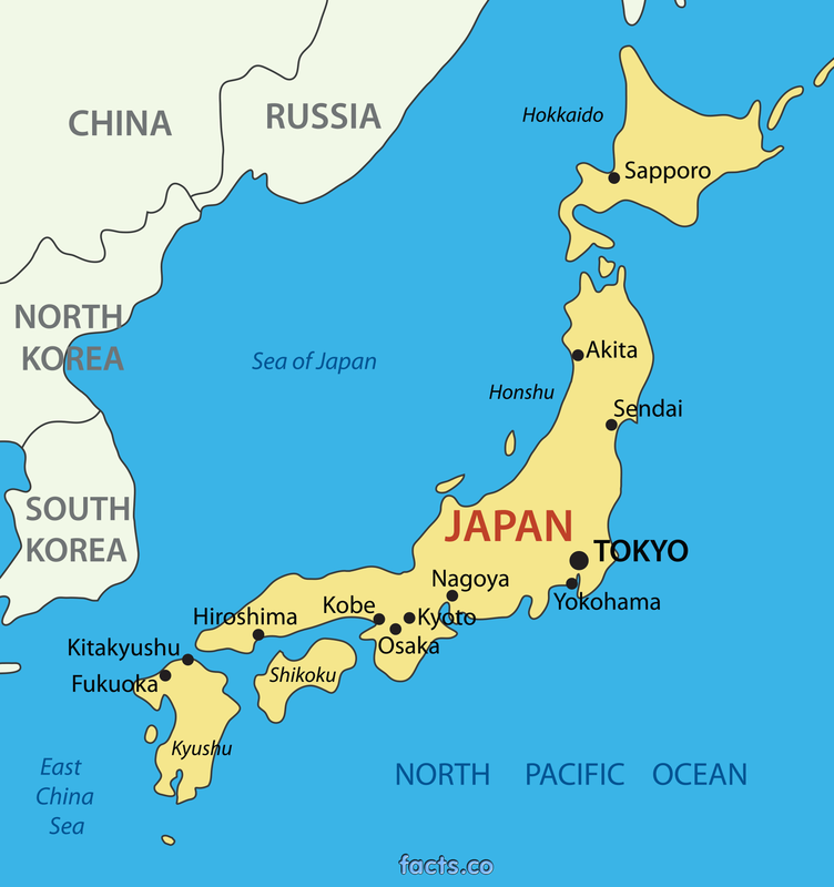
Geography of Japan
Japan is an archipelago, or string of islands, on the eastern edge of Asia. There are four main islands: Hokkaido,
Honshu, Shikoku, and Kyushu. There are also nearly 4,000 smaller islands! Japan's nearest mainland neighbors
are the Siberian region of Russia in the north and Korea and China farther south.
Almost four-fifths of Japan is covered with mountains. The Japanese Alps run down the center of the
largest island, Honshu. The highest peak is Mount Fuji, a cone-shaped volcano considered sacred by many Japanese.
Japan can be a dangerous place. Three of the tectonic plates that form Earth's crust meet nearby and often move against
each other, causing earthquakes. More than a thousand earthquakes hit Japan every year. Japan also has about 200 volcanoes,
60 of which are active.
%20archipelago%2C%20or,Korea%20and%20China%20farther%20south.
Geography of Japan
Japan is an archipelago, or string of islands, on the eastern edge of Asia. There are four main islands: Hokkaido,
Honshu, Shikoku, and Kyushu. There are also nearly 4,000 smaller islands! Japan's nearest mainland neighbors
are the Siberian region of Russia in the north and Korea and China farther south.
Almost four-fifths of Japan is covered with mountains. The Japanese Alps run down the center of the
largest island, Honshu. The highest peak is Mount Fuji, a cone-shaped volcano considered sacred by many Japanese.
Japan can be a dangerous place. Three of the tectonic plates that form Earth's crust meet nearby and often move against
each other, causing earthquakes. More than a thousand earthquakes hit Japan every year. Japan also has about 200 volcanoes,
60 of which are active.

The city of Tokyo and its surrounding
areas are the most populous urban are in the world with an estimated 38 million residents Tokyo is the capital city of Japan as well as the economic center |
|

Torii (pictured above) are traditional Japanese archways marking the entrance to a Shinto shrine. Shintoism is a religion that originated in Japan. Shintoism is the most widely practiced religion in Japan with Buddhism a close second. Most of Japan's population celebrate both Shinto and Buddhist festivals
|
Tokyo
from https://www.britannica.com/place/Tokyo
Tokyo is a city and capital of Japan. It is located at the head of Tokyo Bay on the Pacific coast of central Honshu. It is the focus of the vast metropolitan area often called Greater Tokyo, the largest urban and industrial agglomeration in Japan.
The city is built on low, alluvial plains and adjacent upland hills. The climate is mild in winter and hot and humid in the summer. Early summer and early autumn are rainy seasons; two or three typhoons usually occur during September and October.
The metropolitan area is the largest industrial, commercial, and financial center in Japan. Many domestic and international financial institutions and other businesses are headquartered in central Tokyo. The city is an important wholesale center, where goods from all parts of the country and the world are distributed. Tokyo is part of the Keihin Industrial Zone, centered on the western shore of the bay, which has become the country’s leading manufacturing region. Light and labor-intensive industries predominate in the city, notably printing and publishing and the manufacture of electronic equipment.
Encircled by stone-walled moats and broad gardens, the Imperial Palace, the home of the emperor of Japan, lies at the heart of the city. East of and adjacent to the Imperial Palace is the colorful Marunouchi district, the financial hub and a major center of Japanese business activity. South of the palace is the Kasumigaseki district, containing many national government offices. West of that is Nagatacho, where the National Diet Building (parliament) is located. Tokyo has no single central business district, but the city is dotted with urban centers, usually around railroad stations, where department stores, shops, hotels, office buildings, and restaurants are clustered. In between are less intensively developed neighborhoods with similar mixtures. The buildings in these districts range from stone and brick structures of the Meiji period (1868–1912) to postwar concrete and steel skyscrapers; there are also a dwindling number of wooden, Japanese-style buildings. The brightly lit Ginza shopping district, located in the eastern part of the central city, is world renowned. Northeast of the Imperial Palace, the Kanda district is noted for its many universities, bookstores, and publishers. Although Tokyo’s parks are not as large as those in some major American or European cities, they are numerous and often contain exquisite Japanese gardens.

Tokyo Bay
|

Imperial Palace
|

Ginza District
|

from https://www.worldvision.org/disaster-relief-news-stories/2011-japan-earthquake-and-tsunami-facts#:~:text=A%20magnitude%209.0%20earthquake%20struck,square%20miles%20of%20coastal%20land.
A magnitude 9.0 earthquake struck in the Pacific Ocean off the northeast coast of the Tōhoku region of Japan’s Honshu island on March 11, 2011. The Great East Japan Earthquake — the name given to the event by the Japanese government — triggered a massive tsunami that flooded more than 200 square miles of coastal land. An estimated 20,000 people were dead or missing and close to 500,000 people were forced to evacuate. In addition, a nuclear power plant meltdown triggered a nuclear emergency. The direct economic loss from the earthquake, tsunami, and nuclear disaster is estimated at $360 billion. |
|


Japan's export tree
|

Toyota is a Japanese brand of automobiles. The Rav4 (pictured above) was the best selling passenger car in America in 2020. Toyota also exports the all-electric Prius, Camry and Lexus |


Honda is a brand of Japanese automobiles. The Honda Accord (pictured above) is a popular car in the United States. Honda also makes motorcycles and power equipment such as lawnmowers
|


Sony is a Japanese conglomerate*. The Play Station II is the best selling video game player of all time. Sony also owns Sony Pictures Motion Picture Group which has made such movies as Hotel Transylvania and Men In Black. Sony is the fifth largest television maker in the world.
* a conglomerate is a business with a variety of services or products |
|
Vending machines are popular in Japan
|
|
Pachinko is similar to pinball
|
|
|
|
from https://www.nationalgeographic.org/media/mount-fuji/
Mount Fuji is a symbol of Japan. The mountain contributes to Japan's physical, cultural, and spiritual geography.
Mount Fuji is the tallest mountain in Japan, standing at 3,776 meters (12,380 feet). It is an active volcano, sitting on a "triple junction" of tectonic activity: the Amurian plate (associated with the Eurasian tectonic plate), the Okhotsk plate (associated with the North American plate) and the Filipino plate all converge in the region beneath Mount Fuji. It is only 100 kilometers (62 miles) from Tokyo, Japan's capital and largest city. In fact, the last time Mount Fuji erupted, in 1707, volcanic ash fell on Tokyo.
Mount Fuji is the single most popular tourist site in Japan, for both Japanese and foreign tourists. More than 200,000 people climb to the summit every year, mostly during the warmer summer months. "Huts" on the route up the mountain cater to climbers, providing refreshments, basic medical supplies, and room to rest. Many people start climbing Mount Fuji at night, as better to experience sunrise from the summit—Japan, after all, is nicknamed "the Land of the Rising Sun." The sunrise from Mount Fuji has a special name, Goraiko.
Mount Fuji has been a sacred site for practicers of Shinto since at least the 7th century. Shinto is the indigenous faith or spirituality of Japan. many Shinto shrines dot the base and ascent of Mount Fuji. Shinto shrines honor kami, the supernatural deities of the Shinto faith. The kami of Mount Fuji is Princess Konohanasakuya, whose symbol is the cherry blossom. Konohanasakuya has an entire series of shrines, called Segen shrines. The main Segen shrines are at the base and summit of Mount Fuji, but there are more than 1,000 across all of Japan.

Mount Fuji, Japan
|

Shinto Shrine on Mount Fuji
|

Life Expectancy bar graph
|

Export Destination pie chart
|
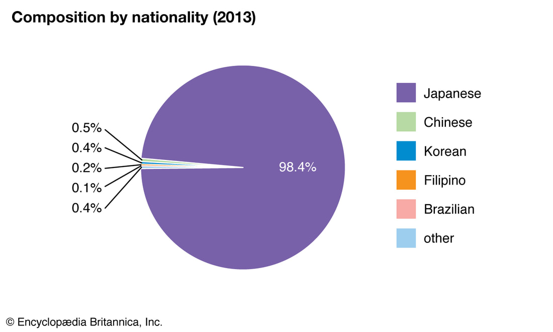
Japanese residents by nationality
|
this is the makeup for the
Japan quiz
some of the answers have changed from the original assignment
answer the questions on a separate piece of paper before completing the assignment on Schoology
the answers to the questions are in the same as order as they appear on the website
Japan quiz
some of the answers have changed from the original assignment
answer the questions on a separate piece of paper before completing the assignment on Schoology
the answers to the questions are in the same as order as they appear on the website
What does the word, hinomaru mean in Japanese? ___(1)___
On which of the four largest islands of Japan is the city of Tokyo?___(2)___
Which body of water is located on Japan's west coast and divides the country from
the Korean peninsula? ___(3)___
What is an archipelago? ___(4)___
Why does Japan experience more than a 1,000 earthquakes each year? ___(5)___
What is the estimated population of Tokyo? ___(6)___
For what activity is the Ginza district known? ___(7)___
In which year did the Great East Japan earthquake occur? ___(8)___
On what date (the day & year) are the 2020 Summer Olympic Games scheduled to begin? ___(9)__
Look at the Population Pyramid
What percent of Japan's current population is over 65 years old? ___(10)___
Look at the Export Tree
What product account for 12% of Japan's total exports? ___(11)___
Which Japanese company produces the Accord automobile? ___(12)___
What is the most popular tourist destination in Japan? ___(13)___
Look at the life expectancy bar graph
What is the life expectancy for a Japanese citizen?___(14)___
Look at the Export Destination pie chart
Which two countries account for almost 40% of Japan's total exports ? ___(15)____
click the XE converter button
$10.00 = ___(16)___ Japanese Yen
assignment for Thursday 22nd April or Friday 23rd April
The Korean Peninsula

flag of the Republic of Korea (South Korea)
|
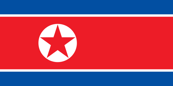
flag of the Democratic People's Republic of Korea (North Korea)
|
from https://www.history.com/topics/korea/korean-war
The Korean war began on June 25, 1950, when some 75,000 soldiers from the North Korean People’s Army poured across the
38th parallel, the boundary between the Soviet-backed Democratic People’s Republic of Korea to the north and the
pro-Western Republic of Korea to the south. This invasion was the first military action of the Cold War. By July, American
troops had entered the war on South Korea’s behalf. As far as American officials were concerned, it was a war against
the forces of international communism itself. After some early back-and-forth across the 38th parallel, the fighting
stalled and casualties mounted with nothing to show for them. Meanwhile, American officials worked anxiously to fashion
some sort of armistice with the North Koreans. The alternative, they feared, would be a wider war with Russia and China–or even,
as some warned, World War III. Finally, in July 1953, the Korean War came to an end. In all, some 5 million soldiers and civilians
lost their lives in what many in the U.S. refer to as “the Forgotten War” for the lack of attention it received compared to more
well-known conflicts like World War I and II and the Vietnam War. The Korean peninsula is still divided today.
|
|

|
from https://www.koreakonsult.com/Attraction_DMZ_eng.html
The Korean Demilitarized Zone (DMZ) is a strip of land running across the Korean Peninsula that serves as a buffer zone
between North and South Korea. The DMZ is a de facto border barrier, which runs in the vicinity of the 38th parallel
north — which divides the Korean Peninsula roughly in half. The 38th parallel was the original boundary between
the United States and Soviet brief administration areas of Korea at the end of World War II. Upon the creation of the
Democratic People's Republic of Korea (DPRK) and the Republic of Korea (ROK) in 1948, it became a de facto
international border and one of the most tense fronts in the Cold War.
NOTE: the border between North and South Korea is closed, meaning that NOBODY can cross the border between two Koreas:
there is no way to travel directly from South Korea to the DPR Korea, or other way around. To travel between Koreas one needs
to transfer to a third country first, for example, to China or Russia. The only place where it is possible to make a couple of
steps into an opposite side is T1-T3 conference rooms also known as blue houses - tent-like one-story buildings sitting just
at the demarcation line.
DMZ is 250 kilometres (160 miles) long, approximately 4 km (2.5 miles) wide. The truce that ended hostilities was signed
here in 1953, but as peace was never agreed to, the two sides are still officially at war over sixty years. There are no troops in
the DMZ itself (except in the JSA*), although both sides of the 4-kilometer strip of land separating the Koreas are the most
heavily armed in the world.

JSA stands for Joint Security Area. This is the one place on the DMZ that North and South Korean military forces stand face to face. The blue buildings are used for conferences between the two countries, and also for tourists.
|
In December of 2017 , a North Korean soldier scrambled across the DMZ, the heavily guarded border that separates North and South Korea, in a bid for freedom that was caught on video.
|

ROK (Republic of Korea) soldiers inspect the fencing separating South and North Korea
|

|
South Korea Geography
from https://kids.nationalgeographic.com/geography/countries/article/ south-korea Korea is a 750-mile-long (1,200-kilometer-long) peninsula located in the easternmost part of the Asian continent. Today, the country is split into South and North Korea, but in the minds of most of its citizens, it remains a single nation that cannot be divided. South Korea has many mountains, but they are small compared with others around the world. Over millions of years, their peaks have been worn down by rain and wind. Most summits are below 3,300 feet (1,000 meters). On South Korea's Jeju Island and along a narrow strip in the south, high humidity and rainfall give rise to tropical evergreen jungles. The peninsula is also surrounded by about 3,000 volcanic islands. |

|
from https://www.thoughtco.com/geography-of-south-korea-1435521
Geographically, South Korea is located on the southern part of the Korean Peninsula below the 38th parallel of latitude. It has coastlines along the Sea of Japan and the Yellow Sea. South Korea's topography consists mainly of hills and mountains but there are large coastal plains in the western and southern parts of the country. The highest point in South Korea is Halla-san, an extinct volcano, which rises to 6,398 feet (1,950 m). It is located on South Korea's Jeju Island, which is located south of the mainland. The climate of South Korea is considered temperate and rainfall is heavier in the summer than in the winter due to the presence of the East Asian Monsoon. Winters are cold to very cold depending upon altitude and summers are hot and humid. |


Samsung Electronic Co. is a multinational corporation based in South Korea.
Samsung is the world's largest manufacturer of consumer electronic devices. It is also the world's largest maker of mobile phones and smart phones. |

South Korea export tree
|

Hyundai Motor Company is an automobile manufacturer based in South Korea. Hyundai Motors is the 2nd largest company in South Korea (after Samsung). The Tucson SUV (pictured above) was Hyundai best selling vehicle in 2019.
|

Average Life Expectancy bar graph
|

Mobile phone subscriptions chart (2015)
|
|
North Korea Geography
from https://www.worldatlas.com/maps/north-korea North Korea covers an area of 120,540 sq. km in the northern half of the Korean Peninsula. As observed on the physical map of North Korea above, the country is very mountainous. Several mountain ranges and uplands area crisscross the country separated by deep narrow valleys. As marked on the map by a yellow upright triangle, the highest peak, Paektu-san on the volcanic Baekdu Mountain, is located on its northern border with China, and rises 9,002 ft. (2,744 m). Important mountains found in the country include the Hamgyong, Rangrim, and Kangnam Ranges. Along the west coast there are wide coastal plains, while along the Sea of Japan (East Sea) coastline (North Korea's lowest point at 0 m), narrow plains rise into mountains. Similar to South Korea, dozens of small islands dot the western coastline. North Korea's longest river is the Yulu (Yalu). Other large rivers include the Tumen, Taedang, and Imjin. The lowest point in North Korea is the Sea of Japan at sea level. |

|
Climate and Average Weather in North Korea
from https://weather-and-climate.com/average-monthly-Rainfall-Temperature-Sunshine-in-North-Korea
North Korea has a continental climate with four distinct seasons. Long winters bring very cold and clear weather
with sometimes snow storms as a result of northern winds that blow from Siberia. The daily average high and
low temperatures for P'yongyang (Capital of North Korea) in January are -3 degrees Celsius (26.6° Fahrenheit) and
-13 degrees Celsius (8,5° Fahrenheit). Average snowfall is approximately thirty-seven days during the winter.
Summer tends to be short, hot, humid, and rainy because of the southern monsoon winds that bring moist air from
the Pacific Ocean. The monthly average high and low temperatures for P'yongyang in August are 29 degrees
Celsius (84° Fahrenheit) and 20 degrees Celsius (68° Fahrenheit). On average, approximately 60 percent of all
precipitation (rainfall) occurs from June to September. Spring and autumn are transitional seasons marked by
mild temperatures and variable winds and bring the most pleasant weather to visit North Korea.

North Korea Export Tree
|
|

North Korea age breakdown bar graph (2018)
|

Road conditions on the Korean Peninsula chart
|
|
|
|
this is the makeup for the
Korean Peninsula quiz
some of the answers have changed from the original assignment
answer the questions on a separate piece of paper before completing the assignment on Schoology
the answers to the questions are in the same as order as they appear on the website
Korean Peninsula quiz
some of the answers have changed from the original assignment
answer the questions on a separate piece of paper before completing the assignment on Schoology
the answers to the questions are in the same as order as they appear on the website
What event started the Korean War? ___(1)___
In which year did the Korean War begin? ___(2)___
During the Korean War, the United States supported South Korea. Which two powerful communist
countries supported North Korea? __(3)__
What do the letters DMZ stand for? ___(4)___
A parallel is the same thing as a line of latitude. What latitude originally divided
North from South Korea? ___(5)___
It is not possible to cross the border between the two Koreas. What must someone do to travel from
South Korea to North Korea? ___(6)___
Look at the map of South Korea
Which large body of water does the city of Incheon (also spelled Inch'on) border? ___(7)___
What city is the capital of South Korea? ___(8)___
What type of landform is Halla-san? ___(9)___
Which South Korean company is the world's largest maker of mobile phones? ___(10)___
Look at the South Korea export tree
What product do South Koreans manufacture that account for 9% of their total exports? ___(11)___
Look at the Average Life Expectancy bar graph
In 2015, how many years could the average South Korean expect to live? ___(12)___
Look at the Mobile phone subscriptions chart from 2015
How more cell phone subscriptions did South Korea have than North Korea? ___(13)___
Look at the map of North Korea
What city is the capital of North Korea? ___(14)___
North Korea borders 3 countries: South Korea, China, and ____(15)___
Which rivers flows through the capital of North Korea? ___(16)___
What is the average high temperature-in Fahrenheit--of the capital of North Korea in January? ___(17)___
Look at the North Korea export tree
What energy resource accounts for 18% of North Korea's total exports? ___(18)___
Which seafood accounts for 4.3% of North Korea's total exports? ___(19)___
Look at the North Korea age breakdown bar graph from 2018
What percentage of the North Korean population is age 60 or above? ___(20)___
assignment for Monday 26th April or Tuesday 27th April
The People's Republic of China

China is officially called, The People's Republic of China
The National Flag of the People's Republic of China has been the national flag since 1949. The Red field symbolizes communism. The large star symbolizes the Chinese people while the four small stars refer to the four social classes in Asian culture. |
The current population of China is 1,443,812,430 as of Friday,
April 23, 2021 making it the most populous country on earth. China's population is equivalent to 18.47% of the world's total population. 
|
China Geography
from https://www.travelchinaguide.com/intro/geography/
Located in Southeast Asia along the coastline of the Pacific Ocean, China is the world's third largest country,
after Russia and Canada. With an area of 9.6 million square kilometers and a coastline of 18,000 kilometers. . .
The vast land expanses of China include plateaus, plains, basins, foothills, and mountains. Defining
rugged plateaus, foothills and mountains as mountainous, they occupy nearly two-thirds of the land, higher
in the West and lower in the East like a three-step ladder.
The highest step of the typical 'ladder topography' is formed by the Qinghai-Tibet Plateau at the average
height of over 4,000 meters, with the Kunlusan Range, Qilianshan Range and Hengduan mountain chain
as the division between this step and the second one. The highest peak in the world, Everest, at 8844.43 meters
high is known as "the Roof of the World".
On the second step are large basins and plateaus, most of which are 1,000 - 2,000 meters high. The
Daxing'an, Taihang, Wu and Xuefeng Mountains divide this step and the next lower one. Plateaus including
Inner Mongolian, Loess, Yungui Plateaus, and basins such as Tarim, Junggar, and Sichuan Basins are situated here.
The third step, abundant in broad plains, is dotted with the foothills and lower mountains, with altitudes
of over 500 meters. Here are located famous plains: the Northeast, the North China, and the
Middle-Lower Yangtze Plains, neighboring with each other from north to south. These well-cultivated
and fertile lands produce abundant crops.
Although the physical features are as described, people tend to divide China into four regions, that is, the
North, South, Northwest and the Qinghai-Tibetan areas. Because of geographical differences, residents of
each region have distinctive life styles and customs.
The North and South regions are located in the Eastern monsoon area and are divided by the Quinling-Huai River.
Nearly 95 percent of the Chinese population lives here. The other two regions, the Northwest and Qinghai-Tibetan
regions that occupy 55 percent of the land, have fewer people, although most of the ethnic groups cluster there.

China map#1
The plateau of Tibet is located along China's border with Nepal and India. The Takla Makan desert is found in China's northwest between the Tien Shan and Kunlun Shan Mountains. Most of China's food is grown in eastern China. China and the country of Mongolia border the Gobi Desert.
|
|

China map#2
Rivers in China flow eastward toward the Yellow Sea, East China Sea and South China Sea. Most Chinese live along the China's east coast.
|

Population Line Graph
India should surpass China's population within ten years. Note how China's population will begin to decrease
after 2030 |

Ethnic Composition of China
Pie chart (2010) Han Chinese are the largest ethnic group in China and the largest in the world
|

China Population Pyramid
China's population is expected to age rapidly in the next decades. Note which age group is the largest
|

Countries' Contribution to the World Economy Chart
This chart shows the amount selected countries contribute to the world's economy. According to the chart, in 2017, China produced 15.4% of the world's total wealth
|
|


Hong Kong
from https://marimari.com/content/hong_kong/general_info/ geography/main.html Hong Kong island sits just south of the Tropic of Cancer . . . Surrounding the country's [Hong Kong] southern coast is the South China Sea. The country [Hong Kong] consists of a peninsular protruding from southeastern China and hundreds of islands scattered off the coast. Kowloon and the New Territories make up the peninsular, while south off the mainland is Hong Kong Island and various other remote islands. Deep waters surround Hong Kong, and with its wide harbors protected by mountains in the north and south, the region is favorable as a passing point for ships. Its geographical location between the Taiwan Straits, the South China Sea, and the Pacific Ocean make it a strategic channel for sea traffic in Asia and the world. Hong Kong was a British colony from 1842 until it was ceded to the People's Republic of China in 1997. |

Hong Kong has a population of 7.5 Million
|
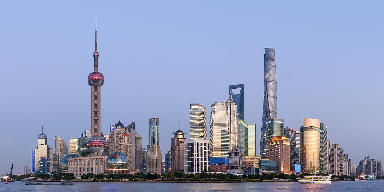
The Shanghai skyline. The tallest building on the left in the Oriental Pearl TV Tower.
It was the tallest structure in China, until the tallest building on the right was built in 2007. The Shanghai World Financial Center is the 2nd tallest building on the world |

Shanghai
from https://www.shanghaihighlights.com/essential/ Shanghai is one of the most populated cities in China. It has a permanent resident population of 23,019,200, of which 12.21 million live in the urban areas. [Shanghai has] the largest base of Chinese industrial technology, one of the most important seaports and China's largest commercial and financial center Shanghai is located where the Yangtze River reaches the East China Sea. Shanghai has a humid continental climate with hot and humid summers. Typhoons are common. |

Lhasa, Tibet
from https://www.travelchinaguide.com/cityguides/tibet/lhasa/ In the Tibetan language, Lhasa means the Holy Land or the Buddha Land. Lhasa is an important world tourist destination, featuring grand snow peaks and glaciers, tranquil grassland scenery, beautiful plateau lakes, changeable geothermal clouds and lush wetlands. There are many historic sites as well. More than 200 temples scattered in the city, such as the Jokhang Temple and Sera Monastery. Lhasa was established in 637 CE as the capital city of the Tibetan Empire. By the 8th century, most of Tibet had converted to Buddhism which it remains today. |

Potala Palace was once a royal residence; now it is a museum
|

The Forbidden City was construct in the early 15th century CE to serve as the imperial palace of the Emperor of China. The rulers of China lived there until the 1920s.
|

Bejing
from https://www.topchinatravel.com/beijing/beijing-facts.htm Beijing, the capital of the People's Republic of China, it is not only the nation's political center, but also a cultural, scientific and educational heart as well as a key transportation hub. Beijing has served as a capital of the country for more than 800 years. from https://www.thoughtco.com/geography-of-beijing-1434413 Beijing has a very large population at 21,700,000. . . Because of China's rapid growth and the introduction of millions of cars into Beijing and surrounding provinces, the city is known for its poor air quality. As a result, Beijing was the first city in China to require emissions standards to be implemented on its cars. Polluting cars have also been banned from Beijing and are not allowed to even enter the city. In addition to air pollution from cars, Beijing also has air quality problems due to seasonal dust storms that have developed China's northern and northwestern deserts due to erosion |
|
Taipei
The city is Taipei is the capital of the Republic of China. It is located on the island of Taiwan. The country of Taiwan was established after World War II when the Chinese communist armies defeated the Chinese Nationalist government in the Chinese Civil War. The Nationalist fled to the island of Taiwan and defended their new home against repeated invasions from the communists. The population of metropolitan Taiwan Taiwan City and the smaller towns and villages surrounding it) is 7 million. Taiwan is a modern city with excellent schools. The city is a major world leader in technology-especially the manufacture of microchips. |
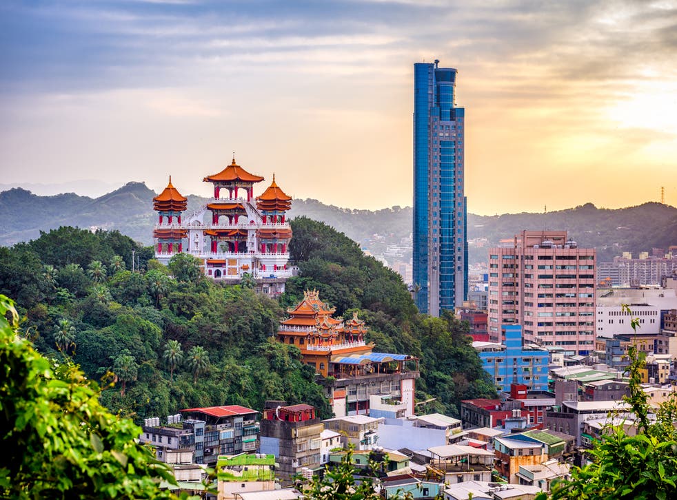
The city of Taipei
|
this is the makeup for the
China makeup exam
some of the answers have changed from the original assignment
answer the questions on a separate piece of paper before completing the assignment on Schoology
the answers to the questions are in the same as order as they appear on the website
China makeup exam
some of the answers have changed from the original assignment
answer the questions on a separate piece of paper before completing the assignment on Schoology
the answers to the questions are in the same as order as they appear on the website
What is the official name of the country of China? ___(1)___
Over 18 % of the world's population is Chinese. What percent of the
world's population is American? ___(2)___
The three most populated countries in the Americas are
the United States, ___(3)___, and Mexico.
Look at China map#1
Which desert is located in the northwest region of China? ___(4)___
Look at China map#2
In which region of China do most Chinese live? ___(5)___
Look at the Population Line Graph
What country is expected to replace China as the world's most
populous country within 10 years? ___(6)____
Look at the Ethnic Composition Pie-Chart
Which group of people is the largest ethnic group in the world? ___(7)___
Look at the China Population Pyramid
Which age group was the largest among the female population of China in 2017? ___(8)___
Look at the "Soccer-Ball" shaped chart titled, "Countries' Contribution to the World Economy Chart"
According to the chart, the United States produced 24.4% of the world's total wealth in 2017 while China produced 15.4%.
Which country produced the third most wealth with 6.13%? ___(9)___
Look at the US-China Trade chart
In 2017, China purchased $16 Billion worth of ____(10)___ from the United States.
In 2017, the United States purchased $77 Billion worth of ___(11)___ from China
Click the button titled, "CIA World Fact Book :China"
In 2018, China imported 9.7% of all is total imports from the country of ___(12)___
18.2% of Chinese practice the ___(13)___ religion
click the button titled, "United Nations Human Development Index"
What is China's overall rank on the Human Development Index? ___(14)___
The port city of Hong Kong is surrounded by the ___(15)___ Sea
The port city of Shanghai is located where the Yangtze River meets the ___(16)___ Sea
The city of Lhasa was once the capital of the ___(17)___ Empire
The Forbidden City, inside the city of Beijing, was where the ___(18)___ lived until the early 20th century
Taipei is the capital city of ___(19)____.
The city of Taipei is located on the island of ___(20)___.
assignment for Thursday 29th April or Friday 30th April
Mongolia

from https://www.goway.com/travel-information/asia/mongolia/geography-and-maps/
Mongolia is located in the landlocked plateau of Central Asia between China and Russian Siberia. It covers an area of 1,564,115 sq km and the population is roughly 3,000,000. |
|

Ethnicities in Mongolia pie chart
|

Religions in Mongolia pie chart
|

Mongolia Population Pyramid
|
Mongolia
from https://www.goway.com/travel-information/asia/mongolia/geography-and-maps/
Mongolia is quite mountainous with three major ranges: the Altai Mountains, the Khangai Mountains and the Khentti Mountains.
The Altai are located in the west and are the highest of the three with much of the area reaching elevations above 2,000m.
The highest point is Hüiten Peak at 4,374m (14,550 ft). The Khangai Mountains occupy much of central and north-central Mongolia.
They are older than the other regions and are therefore lower as they have eroded. The Khentii Mountains are located to the
northeast of Ulaanbaatar near the Russian border.
There are hundreds of lakes in Mongolia with Uvs Lake (covering an area of 3,350 sq km) being the largest. The landscape includes
one of the largest freshwater lakes in all of Asia - Lake Khuvsgul. The three largest rivers in Mongolia are the Orkhon River which
runs for 1,124 km (689 mi), the Kherlen River which runs for 1,090 km (667 mi), and the Selenge River which runs for
539 km (334 mi). Mongolia is also characterized by steppes - large areas of flat, un-forested grasslands, which has resulted
in the Mongolian Steppe being one of the last large and unchanged ecosystems left in the world.
Despite housing hundreds of lakes, Mongolia is also home to the Gobi Desert which makes up for 30% of the entire area of
the country. The Gobi Desert covers parts of northwestern China and southern Mongolia. It measures over 1,610 km
(600 mi) from southwest to northeast and around 800 km (500 mi) from north to south. It is the largest desert in Asia and is
the fifth largest desert in the world.

A yurt is a type of tent that is popular in Mongolia
|
|


Yurts
from https://www.nationalgeographic.org/encyclopedia/yurt/
Yurts have existed for thousands of years in Central Asia, in virtually the same form as they exist today. They are ideal dwellings
for the nomadic cultures of the formidable Central Asian steppe.
The dry, flat grassland of the steppe is a study in extreme weather. It is a very windy biome because no trees, shrubs, or tall grasses
serve as windbreaks. Spring winds can regularly blow up to 9 kilometers per hour (6 miles per hour). The steppe also has an enormous temperature range, from about 24° Celsius (75° Fahrenheit) to -28° Celsius (-19° Fahrenheit).
Yurts are ideally suited to this biome. The circular shape of yurts makes them able to resist winds from any direction. Only the door
of the yurt is vulnerable, and yurt doors are usually very strong and modern. They often have a wooden frame, and sometimes
the door itself is made of wood, as opposed to a flap opening in the felt. This strengthens the door, and the yurt, against the strong
winds of the steppe. The sloping, aerodynamic shape of the roof also means winds are unlikely to tear off roof beams.

Ulaanbaatar is the capital of Mongolia
|

The population of Ulaanbaatar is over 1 million
|
|
|
|
Ulaanbaatar
from https://roadsandkingdoms.com/2016/ulaan-baatar/
Ulaanbaatar is a sprawling, fluid, crazy boomtown. Until about 15 years ago, ‘UB’ was a sleepy capital of about 500,000. Then, international mining firms literally struck gold (plus coal, copper and uranium) in the hills. Long considered a remote satellite of the Soviet world, Mongolia suddenly found itself sitting on up to $1.3 trillion in minerals. Gold rushers flocked to the capital in droves. By 2005, the city’s population had nearly doubled to 947,000 people; today it’s over 1.3 million, making up about 45 percent of Mongolia’s three million souls.
from https://www.npr.org/2019/07/30/727688757/mongolias-capital-banned-coal-to-fix-its-pollution-problem-will-it-work
Welcome to the coldest capital city on earth — Ulaanbaatar, Mongolia — where the temperature can drop to minus 20 degrees
Fahrenheit at night. The city's population has nearly tripled since 1989. Without infrastructure to service all 1.4 million people,
residents off the electric grid are burning raw coal to stay warm.
The result? Winters with extreme air pollution.
Air quality correlates with the thermostat. When temperatures drop, the streets grow hazy. City dwellers walk with their heads
down well into February, noses buried in jackets and face masks. The air pollution stings their eyes and perfumes their clothes
with an acrid, rotten egg smell. Coal dependence is wreaking havoc on Mongolians' health.
The causes go beyond household coal: emissions from the city's coal-fired power plants; motor vehicle exhaust from hundreds
of thousands of cars.
|
|

|
|
Beware the Mongolian Death Worm!!!
from https://roadsandkingdoms.com/2016/ulaan-baatar/
Every nation has its myths and magical creatures. But few are so amusing, so worthy of a SyFy Original Movie, as the olgoi-kharkhoi—the Mongolian Death Worm. A longstanding belief amongst Mongols first revealed to the West in a 1922 account by the paleontologist Roy Chapman Andrews, the Death Worm is by reputation a rare creature that lives deep in the sands of the Gobi. The few who claim to have seen it describe it as a three-foot-long fat worm, dark red, with spikes sticking out of both of its ends. Although sluggish, many fear it for its ability to spit corrosive acidic venom and to discharge a lethal electrical shock at humans and livestock from a great distance. There is no evidence it exists, and some speculate that it might have been a misidentified snake or worm lizard turned mythic over generations of tall tales, but the Death Worm is a fun topic of conversation nonetheless.
Every nation has its myths and magical creatures. But few are so amusing, so worthy of a SyFy Original Movie, as the olgoi-kharkhoi—the Mongolian Death Worm. A longstanding belief amongst Mongols first revealed to the West in a 1922 account by the paleontologist Roy Chapman Andrews, the Death Worm is by reputation a rare creature that lives deep in the sands of the Gobi. The few who claim to have seen it describe it as a three-foot-long fat worm, dark red, with spikes sticking out of both of its ends. Although sluggish, many fear it for its ability to spit corrosive acidic venom and to discharge a lethal electrical shock at humans and livestock from a great distance. There is no evidence it exists, and some speculate that it might have been a misidentified snake or worm lizard turned mythic over generations of tall tales, but the Death Worm is a fun topic of conversation nonetheless.
this is the makeup for the
Mongolia quiz
some of the answers have changed from the original assignment
answer the questions on a separate piece of paper before completing the assignment on Schoology
the answers to the questions are in the same as order as they appear on the website
Mongolia quiz
some of the answers have changed from the original assignment
answer the questions on a separate piece of paper before completing the assignment on Schoology
the answers to the questions are in the same as order as they appear on the website
Mongolia is located between the countries of ___(1)___ and Russia.
Look at the Ethnicities in Mongolia pie chart
The Khalika Mongols are the largest ethnic group in Mongolia.
They makeup ___(2)___% of the population of Mongolia.
Look at the Religions in Mongolia pie chart
53% of Mongolians practice the ___(3)___ religion.
Look at the Mongolia Population Pyramid
The largest age group in Mongolia are males between the ages of 5-9.
The largest female age group is between the ages of ___(4)___.
Read the article titled, Mongolia
The highest mountain (peak) in Mongolia is ___(5)___
A steppe is a type of ___(6)___
The ___(7)___ covers 30% of Mongolia.
Read the article titled, Yurt
What is a yurt? ___(8)___
How does a yurt's shape make it ideal for the life on the Mongolian steppes? ___(9)___
Read the article titled, Ulaanbaaatar
Why did Ulaanbaatar quickly increase in population beginning in 2001? ___(10)___
Ulaanbaatar is the ___(11)___ capital city in the world.
Ulaanbaatar has a serious ___(12)___ pollution problem primarily caused by coal.
Read the article about the Mongolian Death Worm
The Mongolian Death Worm, maybe, lives beneath the sands of the ___(13)___
Besides its ability to spit acid, the Mongolian Death Worm, allegedly*, can kill its victims by ___(14)___.
* allegedly means "it might be true, but no proof exists"
The Philippine Islands

|
from https://theculturetrip.com/asia/philippines/articles/what-does-the-philippine-flag-symbolise/
The sun represents liberty and its eight rays represent the first eight provinces that revolted against Spain. The three stars stand for the three big islands of the Philippines, namely Luzon, Visayas, and Mindanao. As for the colors used, white represents hope for equality, while the blue stripe stands for peace, truth, and justice. Finally, the red stripe symbolizes patriotism and valor. However, when the two stripes are interchanged, this signals that the country is in a state of war. |

|
from https://kids.nationalgeographic.com/geography/countries/article/philippines#:~:text=The%20Philippines%20is%20an%20archipelago,of%20the%20islands%20are%20inhabited.
The Philippines is an archipelago, or string of over 7,100 islands, in southeastern Asia between the South China Sea and the Pacific Ocean. The two largest islands, Luzon and Mindanao, make up for two-thirds of the total land area. Only about one third of the islands are inhabited. from https://www.thoughtco.com/geography-of-the-philippines-1435646 The Philippines, officially called the Republic of the Philippines, is an island nation located in the western Pacific Ocean in Southeast Asia between the Philippine Sea and the South China Sea. The country is an archipelago made up of 7,107 islands and is near the countries of Vietnam, Malaysia, and Indonesia. As of 2018, the Philippines had a population of roughly 108 million people and was the 13th most populous country in the world. |

Manila is the capital city of the Philippines
|

Mount Pinatubo is an active volcano
|

Philippine Trench is one of the deepest sections of the ocean
|
Manila
from https://www.britannica.com/place/Manila
Manila, capital and chief city of the Philippines. The city is the center of the country’s economic, political, social, and
cultural activity. It is located on the island of Luzon and spreads along the eastern shore of Manila Bay at the mouth of the
Pasig River. The city’s name, originally Maynilad, is derived from that of the nilad plant, a flowering shrub adapted to
marshy conditions, which once grew profusely along the banks of the river; the name was shortened first to Maynila and
then to its present form.
Manila has been the principal city of the Philippines for four centuries and is the center of its industrial development
as well as the international port of entry. It is situated on one of the finest sheltered harbors of the Pacific region, about
700 miles (1,100 km) southeast of Hong Kong. The city has undergone rapid economic development since its destruction
in World War II and its subsequent rebuilding; it is now plagued with the familiar urban problems of pollution,
traffic congestion, and overpopulation.
Manila occupies the low, narrow deltaic plain of the Pasig River, which flows northwestward to Manila Bay. The
swampy delta of the southward-flowing Pampanga lies to the north of the city. Immediately to the northeast and east
of the urban region lies a stretch of lowlands, beyond which rise the peaks of the southern range of the Sierra Madre.
Laguna de Bay, the large lake from which the Pasig River flows, flanks Metropolitan Manila to the southeast.
Enclosing Manila Bay to the west is the mountainous Bataan Peninsula. Although the city’s area is constricted, it is an
excellent port site because of its sheltered harbor, its access to inland agricultural areas by way of the river, and its
relative proximity to the Asian mainland.

The Pasig River flows through Manila
|

nilad plant
|

Manila Bay is an excellent harbor because it has deep water so large ships can dock there
|

The largest ethnic group in the Philippines is the Tagalog, but they comprise less than 25% of the population.
|

Most Filipinos practice the Roman Catholic religion.
|

The Philippines is a young country unlike Japan or China. Note how the base of the pyramid (youngest age group) has the longest bar graphs (population).
|
Mount Pinatubo Eruption
The eruption of Mt. Pinatubo in 1991 stands as the second largest eruption in the 20th Century (Mt. Novarupta,
Alaska 1912 claims largest eruption fame). Ash deposits 5 cm (2 in) thick or more covered a land area of about
4,000 square kilometers (1,544 squares miles) burning crops and other plant life around Pinatubo. A typhoon
struck the area after the eruption. The weight of the rain-saturated ash, earthquake shaking and strong winds,
caused numerous roofs to collapse in the communities around the volcano, including at the two large
U.S. military bases Clark and Subic Bay.
More than 350 people died during the eruption, most of them from collapsing roofs. Disease that broke out in
evacuation camps and the continuing mud flows in the area caused additional deaths, bringing the total death toll
to 722 people. The event left more than 200,000 people homeless. Before the eruption, more than 30,000 people lived
in small villages on the volcano.

|
|

|

Philippine Export tree
|

Export Market pie-chart
|

Remittances* by country bar graph
*remittances are money sent home by workers who are employed someplace else
|
The Philippine Trench
from https://www.marineinsight.com/know-more/10-deepest-parts-of-the-ocean/
The third deepest point in the world, the Galathea Depth in the Philippine trench is 10.54 km below sea level. Also known
as Mindanao Trench, this submarine trench is located in the Philippine Sea, spreads in a length of 1,320km and 30km width
in the east of Philippines. Prominent among other trenches in the Philippine Sea, this trench was formed due to a collision
between the Eurasian plate and the smaller Philippine plate.
It is said that the scientists considered the Philippine Trench as the planet’s deepest point until 1970.
According to scientists, the Philippine trench is younger than 8-9 million years ago.

jeepney
from https://theculturetrip.com/asia/philippines/articles/how-the-jeepney-became-a-filipino-national-symbol/ Locally referred to as a jeepney or jeep, this interesting-looking vehicle is an affordable mode of Philippine public transport. With designated routes, which are usually painted on their sides or displayed on their windshields, jeepneys stop anywhere along the way to pick up or let off passengers. |

lumpias
from https://rasamalaysia.com/lumpia-filipino-spring-rolls-recipe/ Almost every country in Asia has its own interpretation of spring rolls, or egg rolls in the United States. In the Philippines, spring rolls are called lumpia. Lumpia is a Filipino word and it comes from the Chinese spring roll, with veggies (like cabbage and carrots), meats (usually pork), and/or seafood (sometimes shrimp) as the filling. |

Moro People
from https://www.bintangrestaurant.co.uk/blog/2019/8/8/eall8091rb4ua41rkmqiopm3oqhhps The Bangsamoro ‘Moro’ people are the native Muslim inhabitants of the Philippines. They are the descendants of the early Malay, Arab and Indian migrants into the Philippine archipelago from as early as the 14th century. The Moro people formed their own ethnic group in southwestern Mindanao, Sulu islands and Palawan. The majority of the Muslims in the Philippines live in the Autonomous Region in Muslim Mindanao (ARMM). Within the Filipino population, there are at least 5 million Muslims across the entire population of the Philippine Islands. |

Blue Ringed Octopus
from https://oceanconservancy.org/blog/2017/03/13/the-blue-ringed-octopus-small-but-deadly/ Native to the Pacific Ocean, the blue-ringed octopus can be found in the soft, sandy bottom of shallow tide pools and coral reefs. When not seeking food or a mate, blue-ringed octopuses often hide in crevices, shells or marine debris. If you catch them outside of their cozy hiding spots, it’s easy to see how the animal gets its name: when threatened, bright blue rings appear all over its body as a warning signal to potential predators. Although all octopuses (as well as cuttlefish and some squid) are venomous, the blue-ringed octopus is in a league of its own. Its venom is 1,000 times more powerful than cyanide, and this golf-ball sized powerhouse packs enough venom to kill 26 humans within minutes. It’s no surprise that it’s recognized as one of the most dangerous animals in the ocean. |

Philippine Spitting Cobra
from https://animalia.bio/philippine-cobra The Philippine cobra is a highly venomous snake native to the northern regions of the Philippines. It has a fairly stocky build, and adult snakes are uniformly light to medium brown, while the juveniles tend to be a darker brown in color. The head is elliptical, depressed, slightly distinct from the neck with a short, rounded snout and large nostrils. The eyes are moderate in size with dark brown and round pupils. Philippine cobras are solitary and only come together to mate. They are mainly terrestrial spending most of the time on the ground. These snakes are active during the night and hide in burrows, holes, rocks, and under vegetation during the midday heat. Philippine cobras are ambush predators; being extremely fast and agile they strike from their hiding spots with amazing speed and subdue their prey with ease. When threatened, these snakes will rise upwards and produce their hood; they are capable of accurately spitting their venom at a target up to 3 meters (9.8 ft) away. |
this is the makeup for the
Philippine Exam
some of the answers have changed from the original assignment
answer the questions on a separate piece of paper before completing the assignment on Schoology
the answers to the questions are in the same as order as they appear on the website
Philippine Exam
some of the answers have changed from the original assignment
answer the questions on a separate piece of paper before completing the assignment on Schoology
the answers to the questions are in the same as order as they appear on the website
On the Philippine flag, the ___(1)___ represents liberty and its eight rays represent
the first eight provinces that revolted against Spain.
The Philippines is an ___(2)____, or string of over 7,100 islands, in southeastern Asia
between the South China Sea and the Pacific Ocean.
In 2018, the Philippines was the ___(3)___ most populous country in the world.
Manila is located along the eastern shore of Manila Bay at the mouth of the ___(4)___ River.
Manila has been the principal city of the Philippines for ___(5)___ centuries.
Look at the Philippines Ethnic Composition pie chart
Tagalog are ___(6)___% of the Philippine population.
Look at the Philippines Religious Affiliation pie chart
About ___(7)___% of Filipinos claim to be Roman Catholic.
Look at the Philippine Population Pyramid
Which age group is the largest among Filipino males? ___(8)___
The eruption of Mt. Pinatubo in 1991 stands as the ___(9)___ largest eruption in the 20th Century.
More than 350 people died during the eruption, most of them from ___(10)___.
Look at the Philippine Export Tree
___(11)___ account for 32% of all Philippine exports.
Look at Export Market pie-chart
The Philippines export about ___(12)___% of all it exports to the United States.
Look at the remittances by country bar graph
In 2017, Filipino workers sent $___(13)___ home.
Before 1970, scientists considered the Philippine Trench to be ___(14)___.
A jeepney is ___(15)___.
In the Philippines, spring rolls are called ___(16)___.
An important difference between the Moro people and the rest of the Filipino population is religion.
While most Filipinos are Roman Catholic, the Moro People practice ___(17)___.
The Blue Ringed Octopus' venom is 1,000 times more powerful than cyanide, and
this golf-ball sized powerhouse packs enough venom to kill ___(18)___ humans within minutes.
When threatened, Philippine Spitting Cobras snakes will rise upwards and produce their hood;
they are capable of accurately spitting their venom at a target up to ___(19) feet away.
Click the button titled, "CIA Fact Book: Philippines"
The first four of Philippines' natural resources are listed as : timber, ___(20)___, nickel, and cobalt.
this is the makeup for the
Vietnam quiz
some of the answers have changed from the original assignment
answer the questions on a separate piece of paper before completing the assignment on Schoology
the answers to the questions are in the same as order as they appear on the website

National flag of the Socialist Republic of Vietnam
|
from https://flagpedia.net/vietnam
The Flag of Vietnam carries colors that are very popular in this part of the world - red and yellow. Red is used as a background and yellow fills the five-pointed star placed in the middle of the flag. The design of the flag refers to the communist past and also it is a symbol of the struggle against the French domination. Each peak of the star represents different population category that contributed to build socialism in Vietnam - peasants, workers, intellectuals, youth, and soldiers. The star should commemorate national unity, which is very important concept for the country that has undergone so many turbulences. Until 1975, Vietnam was divided into northern and southern part, where North Vietnam was supported by China and the USSR and South Vietnam was enjoying the patronage of the USA. After the Vietnam War, the countries have unified again. |
|
from https://kids.nationalgeographic.com
/geography/countries/article/vietnam Vietnam is a long, narrow nation shaped like the letter s. It is in Southeast Asia on the eastern edge of the peninsula known as Indochina. Its neighbors include China to the north and Laos and Cambodia to the west. The South China Sea lies to the east and south. The mountains of the Annam Cordillera rise over most of the western side of Vietnam, while a thousand-mile (1,600-kilometer) coastline dominates the east. At its narrowest point, Vietnam is only 30 miles (48 kilometers) wide. Two of Vietnam's largest rivers, the Mekong in the south and the Red in the north, end at the South China Sea in huge swampy plains called deltas. These regions are home to most of the country's people and provide fertile ground to grow rice and many other crops. |

political map of Vietnam
|

Ethnic Composition pie chart
|

Religious affiliation pie chart
|

Population Pyramid
|
Mekong River
from https://www.britannica.com/place/Mekong-River
Mekong River, Cambodian Mékôngk, Laotian Mènam Khong, Thai Mae Nam Khong, Vietnamese Sông Tiên Giang, Chinese (Pinyin) Lancang Jiang or (Wade-Giles) Lan-ts’ang Chiang, river that is the longest river in Southeast Asia, the 7th longest in Asia, and the 12th longest in the world. It has a length of about 2,700 miles (4,350 km). Rising in southeastern Qinghai province, China, it flows through the eastern part of the Tibet Autonomous Region and Yunnan province, after which it forms part of the international border between Myanmar (Burma) and Laos , as well as between Laos and Thailand. The river then flows through Laos, Cambodia, and Vietnam before draining into the South China Sea south of Ho Chi Minh City (formerly Saigon). Vientiane (Viangchan), the capital of Laos, and Phnom Penh , the capital of Cambodia, both stand on its banks. About three-fourths of the drainage area of the Mekong lies within the four countries the river traverses on its lower course—Laos, Thailand, Cambodia, and Vietnam.

from https://www.worldwildlife.org/places/greater-mekong
This [the Mekong River] is the ‘rice bowl’ of Asia and at its heart lays the Mekong River. Winding almost 3,000 miles from the Tibetan plateau down to the South China Sea, the Mekong River boasts the world's largest inland fishery. It accounts for up to 25 percent of the global freshwater catch and provides livelihoods for at least 60 million people. It is second only to the Amazon River in terms of fish biodiversity. At least 1,100 freshwater species swim the waters of this mighty river including the last remaining populations of the Irrawaddy dolphin, giant freshwater stingray which can weigh up to 1,300 pounds, and the Mekong giant catfish. |

|

from https://www.internationalrivers.org/where-we-work/asia/mekong/
Chinese dam construction on the Upper Mekong is having devastating impacts on downstream communities, and dozens of dams are either planned, under construction or built within the Lower Mekong basin. This rapid expansion of hydropower threatens all countries who share the Lower Mekong Basin, with downstream Cambodia and Vietnam at greatest risk. |

Irrawaddy Dolphins
|

Giant Freshwater (Mekong) Stingray
|

Mekong Giant catfish
|
Vietnam War (1955-1975)
from https://www.history.com/topics/vietnam-war/vietnam-war-history
The Vietnam War was a long, costly and divisive conflict that pitted the communist government of North Vietnam against
South Vietnam and its principal ally, the United States. The conflict was intensified by the ongoing Cold War between the
United States and the Soviet Union. More than 3 million people (including over 58,000 Americans) were killed in the
Vietnam War, and more than half of the dead were Vietnamese civilians. Opposition to the war in the United States bitterly
divided Americans, even after President Richard Nixon ordered the withdrawal of U.S. forces in 1973. Communist forces
ended the war by seizing control of South Vietnam in 1975, and the country was unified as the Socialist Republic of Vietnam
the following year.

Duration of Major US Wars in months, bar graph
|

Total US Casualties by War bar graph
|
Pho
from https://www.allrecipes.com/article/what-is-pho/
Pho is a Vietnamese soup consisting of bone broth, rice noodles, and thinly sliced meat (usually beef).
It may alsobe served with bean sprouts, fresh herbs, limes, chilis, and other garnishes.
The origins of pho are a bit murky, but it is generally believed to have originated in early 20th century
northern Vietnam. It eventually migrated south after the division of the country in 1954, and gained even more
popularity following the Vietnam War as refugees introduced it to other cultures.
|
Ingredients:
|

At glance they might look similar, but pho and ramen are pretty different dishes. Ramen is a Japanese noodle dish made of wheat noodles and a hearty broth, whereas pho is of Vietnamese origin and consists of rice noodles in a light, clear broth.

When people in the U.S. see the word “pho,” they may be inclined to pronounce it like “toe.” This makes sense when you consider some English words that end in a consonant followed by an “o” (so, go, fro, etc.).
Though the most common way to pronounce pho in Vietnam is “fuh” (like “duh”). . . |
Instructions:
|
|
|
|
this is the makeup for the
Vietnam quiz
some of the answers have changed from the original assignment
answer the questions on a separate piece of paper before completing the assignment on Schoology
the answers to the questions are in the same as order as they appear on the website
Vietnam quiz
some of the answers have changed from the original assignment
answer the questions on a separate piece of paper before completing the assignment on Schoology
the answers to the questions are in the same as order as they appear on the website
The official name of of the country of Vietnam is ___(1)___.
___(2)___ is used as a background and yellow fills the five-pointed star
placed in the middle of the flag.
Vietnam is located on the ___(3)___ Peninsula
Vietnam's two major rivers both empty into the ___(4)___ Sea.
Look at the ethnic composition pie chart
Vietnamese is the the largest ethnic group in Vietnam; they account for ___(5)___ % of the population.
Look at the religious affiliation pie chart
Most Vietnamese claim to be non-religious. Which religion do 7.9% of Vietnamese practice?___(6)__
Look at the population pyramid
The largest age group in Vietnam are males between the ages of 25-29. How many
Vietnamese males are between the ages of 25-29.___(7)___
read the Britannica article titled, "Mekong River"
The Mekong River is the ____(8) ___ longest river in the world.
Vientiane (Viangchan), the capital of Laos, and Phnom Penh , the capital of ___(9)___, are
located along the banks of the Mekong River.
The Mekong River is the ‘rice bowl’ of ___(10)___.
The Mekong River accounts for up to ___(11)___ percent of the global freshwater catch.
At least 1,100 freshwater species swim the waters of this mighty river including the
last remaining populations of the Irrawaddy dolphin, giant freshwater ___(12)___ which can weigh
up to 1,300 pounds, and the Mekong giant catfish.
___(13)___ dam construction on the Upper Mekong is having devastating impacts on
downstream communities, and dozens of dams are either planned, under construction or
built within the Lower Mekong basin.
click the button titled, CIA Fact book: Vietnam
The capital city of Vietnam is ___(14)___.
The first four natural resources listed are: ___(15)___, phosphates, coal and manganese.
Read the article titled, Vietnam War
During the Vietnam War, the United States supported the country of ___(16)___ Vietnam against the communists.
Look at the Duration of Major US Wars in months, bar graph
In which country has the longest war in American History been fought?___(17)___
Look at Total US Casualties by War bar graph
Which war in American History resulted in the most casualties? ___(18)__
Look at the Pho recipe
The broth used to make pho requires 4 pounds of ___(19)___
Step #4 of the pho recipe says that the cook should let the broth simmer on low for ___(20) hours
assignment for Monday, 5/17 or Tuesday, 5/18
Thailand

|
from https://www.tourismthailand.org/Articles/plan-your-trip-history-and-geography-geology
Thailand is located in southeast Asia. The country covers an area of 513,000 square kilometers and, when looking on a map, resembles the shape on an axe. To the north it borders Myanmar and Laos and to the east Laos and Cambodia. The south is next to the Gulf of Thailand and Malaysia. Westwards is the Andaman Sea and Myanmar. from https://kids.nationalgeographic.com/geography/countries/article/thailand
Rain falls almost every day between the months of May and September. The moist and humid weather encourages the diverse and abundant wildlife in Thailand. Lotus flowers are common and the favorite flower in Thailand. Lotus flowers live above the surface, but they are rooted in the mud. There are many flowering trees and shrubs, and fruit trees. In the jungle, one can find carnivorous (meat-eating) plants such as the mysterious insect eating pitcher plant. The deep forests are home to tigers, elephants, wild ox, leopards, and the Malayan tapir. The tapir is covered in black fur on the first half of its body and white fur to the rear. Cobras and crocodiles are also found in Thailand. |

lotus flowers
|

insect eating pitcher plant
|

Malayan tapir
|

Thailand Population Pyramid
|

Religion in Thailand pie chart
|

Thailand Ethnicities pie chart
|

|
Andaman Sea
from https://www.britannica.com/place/Andaman-Sea Andaman Sea, marginal sea of the northeastern Indian Ocean. It is bounded to the north by the Irrawaddy River delta of Myanmar (Burma); to the east by peninsular Myanmar, Thailand, and Malaysia; to the south by the Indonesian island of Sumatra and by the Strait of Malacca ; and to the west by the Andaman and Nicobar Islands, which constitute a union territory of India. Through such ports as Bassein, Mawlamyine, Tavoy, and Mergui—as well as Yangon(Rangoon) itself—it forms the most important sea link between Myanmar and other countries; it also forms part of a major shipping route between India and China, via the Strait of Malacca. The sea, which has an area of 308,000 square miles (798,000 square km), takes its name from the Andaman Islands. |
Bangkok
from https://www.britannica.com/place/Bangkok
Bangkok, Thai Krung Thep, city, capital, and chief port of Thailand. It is the only cosmopolitan city in a
country of small towns and villages and is Thailand’s cultural and commercial center.
Bangkok is located on the delta of the Chao Phraya River, about 25 miles (40 km) from the Gulf of Thailand. It was formerly
divided into two municipalities--Krung Thep on the east bank and Thon Buri on the west—connected by several bridges.
In 1971 the two were united as a city-province with a single municipal government. In 1972 the city and the two
surrounding provinces were merged into one province, called Krung Thep Maha Nakhon (Bangkok Metropolis).
The metropolis is a bustling, crowded city, with temples, factories, shops, and homes juxtaposed along its roads and canals.
It is also a major tourist destination, noted for bountiful cultural attractions and a nightlife.
The climate of Bangkok is hot throughout the year, ranging from 77 °F (25 °C) in the “cold” season in December to 86 °F (30 °C)
at the height of the hot season in April. The mean annual rainfall totals 60 inches (1,500 mm), four-fifths of which falls in
brief torrential downpours during the late afternoons of the rainy season, which lasts from mid-May through September;
the dry season lasts from December to February. Mean monthly relative humidity varies from a low of 60 percent in
the cold season to more than 80 percent during the rainy season.

from https://www.hotels.com/go/thailand/bangkok-things-you-didnt-know
Bangkok Population Bangkok's 2021 population is now estimated at 10,722,815. In 1950, the population of Bangkok was 1,360,000. Bangkok has grown by 183,400 since 2015, which represents a 1.74% annual change. These population estimates and projections come from the latest revision of the UN World Projects. These estimates represent the Urban agglomeration of Bangkok, which typically includes Bangkok's population in addition to adjacent suburban areas. |

from https://www.hotels.com/go/thailand/bangkok-things-you-didnt-know
Bangkok Weather According to the World Meteorological Organization, Bangkok is the world’s hottest city. The average air temperature throughout the year is 28°C*, but this jumps to a sticky 34°C* between March and May. 28 degrees Celsius = 82.4 degrees Fahrenheit
34 degrees Celsius = 93.2 degrees Fahrenheit |

from https://www.hotels.com/go/thailand/bangkok-things-you-didnt-know
The Red Bull energy drink can be found throughout the world and was the pioneer of what is now a multibillion-dollar power drink industry. But few people know that this caffeine-and-sugar concoction has been a popular brand in Thailand since 1976, when it was created by Chaleo Yoovidhya, a man with little formal education who had moved to Bangkok from central Thailand to seek his fortune. At the time of his death in 2012, he was reportedly the third richest man in Thailand with an estimated wealth of $US 5 billion. |

muay thai
from https://www.tigermuaythai.com/about-muay-thai/history Muay Thai or Thai Boxing is the national sport and cultural martial art of Thailand. It was developed several hundreds of years ago as a form of close-combat that utilizes the entire body as a weapon. Muay Thai has progressed significantly over the past 100 years. Due to the noticeable national popularity, it began to garner international recognition and exposure. In World War II, after formally being introduced to Muay Thai, foreigners named it “Siam Boxing”, as Thailand was formerly Siam. The French labeled it as “Le Sport Orient” or the fighting style of the orient. Soldiers from Europe and America would watch attentively as the Thai soldiers practiced Muay Thai amongst themselves. They were so impressed with the style of fighting that they asked the Thai soldiers to teach them the fundamentals and traditions of Muay Thai. As it became more popular internationally, the rules began to change so it could be better organized and governed like established sports such as boxing. Today Muay Thai is becoming very popular on a global scale. It was recently accepted as an Olympic sport, finally gaining it’s deserved recognition. |

sea krait
from https://murexdive.com/banded-sea-kraits-north-sulawesi/ While most people call this species the “banded sea krait”, it is also known as the “banded sea snake” or the “yellow-lipped sea krait”. It also has its scientific species name which is “Laticauda colubrine” which has given rise to yet another common name “colubrine sea krait”. The term “krait” refers to a large group of venomous snakes found in Asia. The key distinguishing physical characteristic of sea snakes and kraits compared to land living snakes is in the tail. A sea snake or kraits tail is flattened to give it a paddle-like effect which it uses for swimming through the water. While true sea snakes spend almost all of their time underwater, sea kraits return to land to digest their prey, rest and to reproduce. Juveniles spend more time in the water than on land whereas adult banded sea kraits spend equal amounts of time underwater as they do terrestrially. When on land a banded sea krait can only move at around one 5th of the speed it does in the water but most other species of krait and sea snake are entirely stranded on land and cannot move at all. |

pad thai
from http://www.lionbrand.com.au/blog/pad-thai- history-and-origin Pad Thai is a stir-fried rice noodle dish that is a signature street food of Thailand. It is made with soaked dried rice noodles, which are stir-fried with eggs and chopped firm tofu, and is flavored with tamarind pulp, fish sauce, dried shrimp, garlic or shallots, red chili pepper and palm sugar and served with lime wedges and often chopped roasted peanuts. Internationally, Pad Thai is probably the most well known dish of all Thai cuisine on considered the national dish of Thailand. . . . . . . Many restaurants choose not to compete with the street-food vendors in Thailand, who have perfected the recipe as they make and serve only pad Thai all day long. Despite it's status as the national dish, its origins aren't particularly Thai. Noodles and stir fries are quintessentially* Chinese. . . Even the dish’s full name, kway teow pad Thai nods to its Chinese origins (kway teow is Chinese for rice noodles). *quintessentially means something (stir fry cooking) is a perfect example of something else (Chinese culture) |

Thailand's Exports bar graphs
|
|

Rice Exports Chart
|
|
|
|
|
Complete the Thailand quiz MAKEUP
some of the answers have changed from the original assignment
answer the questions on a separate piece of paper before completing the assignment on Schoology
the answers are in the same order as they appear on the website
some of the answers have changed from the original assignment
answer the questions on a separate piece of paper before completing the assignment on Schoology
the answers are in the same order as they appear on the website
The flag of Thailand shows three colors: red, white and ___(1)___.
The four countries which border Thailand are: Cambodia, Laos, Malaysia and ___(2)___.
Look at the population pyramid
There are about ___(3)___ million Thailand Females between the ages of 40-44.
Look at the Religion in Thailand pie chart
Most of the citizens of Thailand practice the ___(4)___ religion.
Look at the Thailand Ethnicities pie chart
About ___(5)___% of the citizens of Thailand belong to the Thai ethnic group.
read the section titled, "Andaman Sea"
The Andaman Sea is bounded (bordered) to the south by the
Indonesian island of ___(6)___ and by the Strait of Malacca.
read the section titled, "Bangkok"
Bangkok is located on the delta of the ___(7)___ River.
The mean annual rainfall totals ___(8)___ inches.
Bangkok's 2021 population is now estimated at ___(9)___.
According to the World Meteorological Organization, Bangkok is the world’s ___(10)___city.
Bangkok resident, Chaleo Yoovidhya, created ___(11)___ in 1976.
French visitors to Thailand labeled Muay Thai as “___(12)___” or the fighting style of the orient.
Muay Thai was recently accepted as an ___(13)___, finally gaining it’s deserved recognition.
The term “krait” refers to a large group of venomous ___(14)___ found in Asia.
Pad Thai is made with soaked dried rice noodles, which are stir-fried with ___(15)___ and chopped firm tofu.
Usually, pad thai is served with ___(16)___ and often chopped roasted peanuts.
Even though pad thai is the most popular dish in Thailand, it was probably invented in ___(17)___.
Look at the Thailand's Exports bar graphs
In September 2019, the export commodity that increased over 110% from September 2018 was ___(18)__.
In September 2019, the export commodity that decreased over 28% from September 2018 was ___(19)___.
Look at the Rice Exports Chart
In both 2018 and 2019, the country of ___(20)___ the most rice.
In 2020, Thailand was expected to export ___(21)___ million tonnes of rice