Human Geographic Systems
Unit vocabulary
location – a specific point on the Earth’s surface
place – an area distinguished by unique physical and human characteristics
region – a spatial division of the Earth’s surface that shares a common characteristic
formal region – area of the Earth’s surface that is unified by a measurable physical of human characteristic
functional region – area of the Earth’s surface that is defined by an interaction or connectivity
perceptual region – area of the Earth’s surface that is defined by a perception of the people living there or by the general society and may not be based on objective data
cultural landscape – the physical setting created by humans that reflects the identity and culture of the area
free enterprise – economic system in which private individuals own businesses to make profits and economic decisions are made by producers in response to consumer demands
socialist economic system – economic system in which some large-scale business enterprises are government-owned and operated for the benefit of society
communist economic system – economic system in which the means of production are owned by the government for governmental control of the resources
primary economic activities – economic activities focused on the extraction of natural resources
secondary economic activities – economic activities focused on the manufacturing of goods
tertiary economic activities – economic activities focused on the delivery of services
quaternary economic activities – economic activities focused on management, information processing, or research
14 Sept. (A-Day) or 15 Sept. (B-Day)
Regions and the Human Development Index

How the Character of a Place is Related to its political, Economic, Social, and Cultural Elements
Character of a place refers to the physical and human geographic characteristics that distinguish a particular place. Physical geographic factors such as climate, vegetation, and human geographic characteristics such as settlement patterns, population density relate to the character of a place as do the political, economic, social and cultural features that make a place unique. Since these features can change over time the character of a place can change over time also.
Character of place can be analyzed on a macro level such as examining the character of a culture region or on a micro level, such as examine the character of a city or neighborhood.
Political, Economic, Social, and Demographic Indicators to Determine the Level of Developments and Standard of Living in Nations
Human Development Index (HDI)- refers to the ranking of nations done by the United Nations based on a composite data; intended to measure human development; the index is based on a measure of basic facets of human development, including a decent standard of living, long and healthy life, and education
The HDI provides data which allows for a glimpse of current conditions as well as an examination of long-term trends
Physical and/or Human Factors that Constitute a Region
Physical factors that constitute a region include common landforms, vegetation, climate, biomes
Human factors that constitute a region many include culture regions, trade networks, religion, language, political units, supranational organization, trade corridors
Different Types of Regions
Geographers examine the world by dividing it spatially into regions. Regions all have spatial extents and boundaries. Regions vary in size and are generally categorized as formal, functional or perceptual.
Formal regions refer to spatial areas that are unified by a physical or human geographic factor. Examples may include culture regions, political entities, climate zones, biomes.
Functional regions refer to spatial systems that are defined by an interaction or connectivity. Examples may include trade corridors, metropolises, business districts, spheres of influence.
Perceptual regions are less structured than formal and functional regions and are constructed around a reality that is perceived by the people living in the area or the general society. Perceptual regions are not based on objective data. Examples may include “Dixie”, vernacular regions, “Chinatown”, gang “turfs”, “Bible belt”, “Rust belt”

|

|

|

You will nee a piece of paper to write down the geographic information from the Human Development Index.
Click the button titled, "Human Development Index". You'll see the names of all the countries in the world.
#1 click "Argentina". What is Argentina's ranking among the world's developed countries?
#2 click "Brazil". What is Brazil's ranking among the world's developed countries?
#3 Click "Canada". Scroll down until you see "Health". How many years do residents of Canada typically live? (Life Expectancy at Birth)
#4 Click "Colombia". How many years do residents of Colombia typically live?
#5 "Click "Costa Rica". Click the "+ Health". Find "Mortality rate, infant (per 1,000 live births)". What is the infant death (mortality)
rate in Costa Rica?
#6 Click "El Salvador". What is the infant death (mortality) rate in El Salvador?
#7 Click "Guatemala". Click the "+ Education". Find "Literacy rate (people who can read), adult (% over 15 and over). What % of Guatemalans can read?
#8 Click "Grenada". What % of Grenadians can read?
#9 Click "Honduras". Click "+ Work, employment and vulnerability" . What % of Hondurans work (employed) in agriculture?
#10 Click "United States". What % of Americans work in agriculture?
|
(2019) United Nations Development Program video (2:28) on latest Human Development Report
|

|
(2017) National Geographic video (2:43) on happiness as a measurable factor in development
|
16 September (C-Day)
for students who have been absent, or are new to the class, or want another attempt to improve their grade
17 September (A-Day) or 18 September (B-day)
Economic Geography
The Forces that Determine the Distribution of Goods and Services in Traditional, Free Enterprise, Socialist, and Communist Economic Systems
Free Enterprise
The production of goods and services in a free enterprise system are determined by consumer demand for products. Free enterprise is characterized by private ownership of businesses and economic decisions are made by the business owner responding to consumer demand.
Socialist
A socialist economic system is characterized by government ownership and operation of large scale industries, such as health care, schools, utilities and mass transportation. Smaller businesses are privately owned and do respond to consumer demand.
Communist
A communist economic system is characterized by government control of all economic decisions.
|
(2014) University Now video (2;24) on the different types of economies
|

Diagram showing that countries all have mixed economic systems though some lean more toward planned or free market systems
|
(2015) CBS Sunday Morning video (4:40) on the success of In and Out Burger
|
(2019) CNBC video (7:39) on the success of Starbucks
|

|
(2019) CNBC video (11:45) on the fast food competition for the chicken sandwich market
|
Export diagrams
Using Wikipedia, type the name of country. Then using the table of contents, click "economy". This will take you to a
color-coded diagram of that countries export market.
Using Wikipedia, type the name of country. Then using the table of contents, click "economy". This will take you to a
color-coded diagram of that countries export market.
#1 What valuable commodity accounts for 11% of Mexico's export market?
#2 What type of consumer good accounts for 8% of Mexico's export market?
#3 What type of agricultural product accounts for 17% of Nicaragua's export market?
#4 What valuable commodity accounts for 6.6% of Nicaragua's export market?
#5 What type of agricultural product accounts for 11% of The Bahamas export market?
#6 Go to the start of The Bahamas section titled "Economy" and look under "tourism".
What percent of The Bahamas economy is based on tourism?
#7 Over 75% of Haiti's export market is based on one type of manufactured good. On the diagram they are colored green.
What type of good are all the products shaded green?
#8 What type of agricultural product accounts for 10% of Honduras' export market?
#9 What valuable commodity accounts for 50% of Ecuador's export market?
#10 What type of agricultural product accounts for 12% of Ecuador's export market?
#11 What valuable commodity (usually used to make coins) accounts for 16% of Cuba's export market?
#12 What type of consumer good accounts for 10% of Cuba's export market? (This product is illegal to import into the United States).
#13 What valuable commodity accounts for 37% of Bolivia's export market?
#14 What valuable commodity accounts for 12% of Ecuador's export market?
(In the US, pennies are composed of 98% of this metal-not copper)
21 September (A-Day) or 22 September (B-Day)
Development and Economic Production
Way People Satisfy Their Basic Needs Through the Production of Goods and Services
People who practice subsistence farming produce enough agricultural output to provide for the needs of their family. In comparison, commercial agriculture is characterized by agricultural surplus output that is sold for profit.
Cottage industries are characterized by the small-scale production of goods done generally in a home-based setting, such as weaving cloth. In comparison commercial industries produce in a larger setting, such as a factory, produce a larger amount of goods, and employ more workers
|
(2017) Great Big Story video (3:00) on farming in Kenya. an inventor working from home (cottage industry) expanded his idea to produce a machine that increases sisal production.
|

In less developed economies, the primary sector will comprise the biggest part of the economy. Typically as an economy develops, increased labor productivity will enable workers to leave the agricultural sector and move to other sectors, such as manufacturing and the service sector.
from https://www.economicshelp.org/concepts/primary-sector/ |
(2019) CNBC video (8:54) on Tesla's Gigafactory in Nevada. Increasingly, much of the manufacturing work done in the United States includes robotics.
|
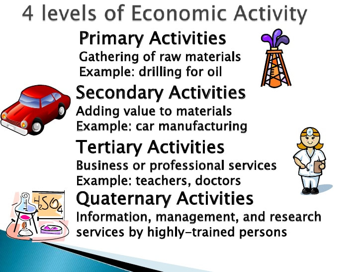
Connections Between Development and Economic Activities
Developing countries rely more on primary and secondary economic activities, while developed countries rely more on tertiary and quaternary activities. More developed countries are able to offer more service-oriented jobs, while importing raw materials and manufactured goods from developing countries.
Primary activities include those jobs focused on raw extraction of natural resources (e.g., mining, agriculture, fishing), secondary activities are jobs focused on manufacturing goods (e.g., manufacturing, construction), tertiary activities include those in the service sector (e.g., transportation, sanitary services, commerce and trade), and quaternary activities involve jobs related to information processing and management (e.g., finance, computer industry, high education, research).
|
(2017) Ted-Ed video (6:03) on how fracking works. Fracking extracts resources so it is a primary activity
|
|
(2019) TED-Ed Series video (4:31) on aquaculture
|

Farming is a Primary Economic Activity
|

Manufacturing is a Secondary Economic Activity
|

Teaching is a service and a Tertiary Economic Activity
|
Information and Data Processing is a Quaternary Economic Activity
|
On a piece of paper identify whether the following economic activities are (A) primary, (B) secondary, (C) tertiary or (D) quaternary
#1 a prospector mines for gold in Alaska
#2 a farmer grows shrimp in an inland fish pond
#3 an UBER driver transports customers in the city of Los Angeles
#4 a math teacher teaches algebra at a public high school
#5 a factory worker designs and makes jewelry from silver
#6 a high school student works part-time at Kane's Chicken Restaurant
#7 a scientist working for a drug company researches a cure for the Covid 19 virus
#8 a tailor mends (repairs) torn clothing at her home
#9 a doctor treats a burn victim
#10 a bilingual worker answers phones at a call center
#11 a mathematician develops a new computer program to allows robots to complete complex tasks
#12 a farmer grows jalapeno chilis in New Mexico
#13 a truck driver transports chilis to a food processing factory
#14 a factory worker cleans and removes the the seeds from jalapeno chilis be putting them in cans
#15 a Walmart employee stacks cans of jalapeno chilis on a shelf
#16 a team of scientists alter the DNA of a plant to make a new variety of chili that can resist drought
24 September (A-Day) or 25 September (B-Day)
6 Weeks Exam
you will need to record information on a piece of paper before starting the exam
Part 1
Using the 2019 Human Development Index record the following information for the countries listed below (1) Human Development Index ranking, (2) Life expectancy at birth (years), (3) Mortality rate, infant (per 1,000 live births), (4) Literacy rate, adult (% ages 15 or older), (5) Total population (millions) and (6) Median Age (years).
Mexico, Canada, Brazil, Argentina and United States
Human Development Index ranking is on the first page
Life Expectancy and the Infant Mortality rate are found under the "Health" tab
Literacy rate is found under the "Education" tab
Total Population and Median Age are found under the "Demography" tab
If n/a appears then write that down
Part 2
Use Wikipedia to research the Color-coded Export Diagrams and write down the largest export for each of these countries:
Mexico, Guatemala, Suriname, Dominican Republic, and Dominica
Part 3
Be prepared to identify whether selected economic activities are (A) primary, (B) secondary, (C) tertiary or (D) quaternary
Part 4
Go to the Schoology page, and open the exam in the Week Six folder. Use your notes to answer the questions
28 September (A-Day) or 29 September (B-Day)
|
(2016) CBS News video (5:44) on cartography
|

Thematic map of the United States
Which icons are used to describe Texas? Which icons are used to describe Nevada? Which icons are used to describe Florida? |

Political Map of the United States
Why do political maps of the United States become difficult to read when you look at New England? |
Electoral Maps
These maps show the results of Presidential Elections. The numbers shown within the state borders indicate the number of electoral votes assigned to each state. States with large populations (California, Texas, Florida, New York) have the most electoral votes. Each state is guaranteed at least 3 votes.
These maps show the results of Presidential Elections. The numbers shown within the state borders indicate the number of electoral votes assigned to each state. States with large populations (California, Texas, Florida, New York) have the most electoral votes. Each state is guaranteed at least 3 votes.

2016 Presidential Election Electoral Map
How many states in the Southern US did Lincoln win? Which 3 states have the most electoral votes, and how did they vote? The 1860 Election occurred just prior to start of the American Civil War. Civil. Abraham Lincoln's Republican Party won. The Republican Party was considered the anti- slave party.
The Strength of the Democratic Party was in the South States. During this time the Democratic Party represented farmers (especially cotton) and rights of state governments to nullify (disregard) federal laws. |

2008 Presidential Election Electoral Map
Which candidate won Florida's electoral votes? Which candidate won Texas' electoral votes? Which candidate won California's electoral votes? Barrack Obama won the 2008 election and later, won again in 2012.
At this time, the political parties have "switched"- the Republican Party is now strongest in the South. The Democratic Party voters are found along the Pacific Coast and Atlantic Coast. Democratic Party was the party of minority empowerment and expanded government services (Obamacare) |

2016 Presidential Election Electoral Map
Which candidate won Florida's electoral votes? Which candidate won Texas' electoral votes? Which candidate won California's electoral votes? Donald Trump won in 2016 because the Republican Party won the South, the Great Lake States (Michigan, Ohio, Wisconsin) and Florida. In 2016, Republican Party generally represented the interests of big business (tariffs on Chinese imports), religious conservatives (Supreme Court selections) and nationalism ("America First").
|
An examination of maps showing political boundaries may illustrate the extent of territorial control a
political power currently yields or has in the past.
political power currently yields or has in the past.

Historical Map showing the territorial expansion
of the United States What territories were purchased from other countries? |
Political Map showing the political boundaries of the 7 countries of Central America
What is the only Central American country without a coastline on the Caribbean Sea? Use the Human Development Index to find the population and median age of Honduras Honduras' leading export is clothing (sweaters, pullovers, T-shirts). What is Honduras' leading agricultural export? |

Road Map of El Paso, Texas. The focus is on transportation routes.
Which US Interstate passes through El Paso, Texas? There was a time when fold-out paper maps were found in every glove box in every car in America. Why are paper versions of this type map no longer used? |

Visitor's Map, also called a Tourist Map of Downtown El Paso.
What different types of locations are shown on this map? |
30 September (C-Day)
maps, graphs and charts
Part I. Thematic maps

Thematic Map of Massachusetts
Which famous ship can you visit in the town Plymouth? What is a Chickadee? |

Thematic Map of National Parks
Which National Park is located near the city of Miami, Florida? Which national Park is north (on the map above) the city of Phoenix, Arizona? |

Thematic Map showing the Most Famous Brand From Each State In The US
What brand is shown in Texas? What brand is shown California? What brand is shown in Oregon? What brand is shown in the state of Washington ? |
Part II. Political maps

Political map of the United States
If you travel directly west by car from El Paso, Texas to San Diego, California, through which two states must you pass? Which city is the capital of Florida? In which state does the Rio Grande begin? |

New Mexico Highway Map
Which US Interstate connects Las Cruces, New Mexico to Albuquerque? |

2012 Electoral Map
Which candidate won the state of Florida? Which candidate won the state of Texas? How many total Electoral votes did President Obama win n 2012? |
Part III. Graphs
|

Multiple Line Graph of Sales made by Month and Year
What was the sales amount in April of 2016? What was the sales amount in April of 2018? |
Part IV. Charts

Population Chart of the 15 Fastest Growing Cities and towns in the United States Which Texas city grew by 6.5% between 2016 and 2017? What was the population of McKinney, Texas in 2017? |

Pie Chart of the Percentage of Permanent Immigrant Admitted into The US by Country of Origin in 2018
Which group of immigrants made up 5.9% of the total immigrants to the US in 2018? What percent of people from the Philippines were part of the total US immigration? |

"Pop Chart" of the Most Popular Soft Drinks in the US by Millions of Cases Sold in 2010
Which soft drink was the most popular in the US in 2010? How many millions of cases did (regular) Dr. Pepper sell in 2010? |
Part V. online resources
Identify the Human Development Index ranking for China, United States and Japan
1 October (A-Day) or 2 October (B-Day)
maps, graphs and charts exam
Part I. Maps

Political Map of the United States w/ State Capitals
Which city is the capital of California? In which Southern state is the capital city of Baton Rouge? Which two states border Florida? |

2016 Presidential Election Map w/Electoral Vote Results
How many electoral votes did the state of Texas have in 2016? How many electoral votes did the state of Alaska have in 2016? |

Political Map of Central America
How many countries are part of Central America? (Jamaica and Mexico are not included) In which country is the city of San Jose? Which Central America country does not border the Caribbean Sea? |
Part II. Graphs

Multiple Line Graph of Sales made by Month and Year
What was the sales amount in December of 2016? What was the sales amount in December of 2018? |

Climograph of Dallas, TX
How much rain does Dallas, Texas receive the month of October? What is the average temperature in the month of July? |

Bar graph of the top 10 fast-food locations, by number of locations worldwide
Which pizza restaurant has the most locations in the world? Which restaurant is ranked 10th? Which national fast food restaurants are not on this list? |
Part II. Charts

Top 12 Most Populated US Cities in 1950 w/ Current Demographic Information
St. Louis was the 8th most populated city in the US in 1950. What was its rank in 2016? How many people lived in the city of San Francisco in 1950? Which US city lost over 1 million residents from 1950 to 2016? Which US city's population increased over 100% between 1950 and 2016? |

Names of Hurricanes from 2016 to 2021
The letter "L" is the 12th letter. In 2016, the 12th hurricane was named Lisa. What was the 12th hurricane in 2020? What will be the name of the 1st hurricane of 2021? |

Pie Chart of the Percentage of Permanent Immigrant Admitted into The US by Country of Origin in 2018
Which group of immigrants made up 5.5% of the total immigrants to the US in 2018? What percent of people from Mexico were part of the total US immigration? |
Part IV. online resources
What is the Life Expectancy in the United States, Haiti, Mexico and Afghanistan?
5 October (A-Day) or 6 October (B-Day)
Governments

The Ancient city state of Athens is often called the birthplace of democracy
|

North Korea is a dictatorship governed by Kim Jong Un. The Korean peninsula is divided by a demilitarized zone
|

Great Britain is Constitutional Monarchy where the royal family has limited power. Queen Elizabeth II (center in blue) is married to Prince Philip (on her left). Together they have four children. Their oldest child (standing to her right) is Prince Charles.
|
Various Forms of Governments in Specific Countries
Democracy
is a form of government where the ultimate power is derived from the people.
Dictatorships
are characterized by entire political power being invested in one single person or group such as North Korea and Cuba.
Monarchy
is a form of government in which the power is vested in one individual and is typically acquired through heredity. Constitutional monarchies are characterized by a sharing of power
between the monarch and representative and executive bodies. Examples include Britain and the Netherlands.
Republics
are those governments in which the head of government is not a monarch. Republics can be democratic (ruled by the people) such as the United States and Australia,
theocratic (ruled by religious law) such as Iran, or parliamentary (having a head of government separate from the monarch such as Britain).
In China representatives are chosen at the local level, local officials then vote for national leaders, all chosen from the communist party. While a republic in name,
in practice it is not reflective of democratic processes.
Theocracy
is a form of government lead by religious leaders who claim divine inspiration with citizens’ rights based on religious teachings.
Totalitarianism
is a form of dictatorship that seeks to control all aspects of social life within a country. Historical examples include Nazi Germany and the Soviet Union.
Currently North Korea serves as an example.
|

China is another oligarchy. Xi Jinping is the President of the People's Republic of China and General Secretary of the Chinese Communist Party. China's 2020 population is estimated at 1.4 billion people which is equivalent to 18.47% of the total world's population.
|


After reviewing the information go to the Week Eight folder in Schoology and complete today quiz
8 October (A-Day) or 9 October (B-Day)
Hurricane Delta Report (from CNN)
Review CNN's report on Hurricane Delta on the website; then, fill in these 10 questions on a piece of paper.
After writing down your answers, go to Week Eight Folder on Schoology and take the quiz
After writing down your answers, go to Week Eight Folder on Schoology and take the quiz
#1 Hurricane Delta is over the Gulf of Mexico and has strengthened into a Category _____
#2 Delta is expected to landfall along the northern U.S. Gulf Coast on Friday, most likely in ___________.
#3 Hurricane Delta will land in areas ravaged by Hurricane _________ in late August.
#4 Look at the color-coded map titled, "Hurricane Delta 8 AM ET" Which two cities are in the purple colored area indicated Hurricane warning?
#5 A storm surge watch is also in effect from High Island, Texas, to Sabine Pass, Texas, and also east of Ocean Springs, Mississippi, to the Mississippi-Alabama border. This watch means a dangerous, ____________________ is possible within 48 hours.
#6 Tropical storm warnings are in effect from San Luis Pass to Sabine Pass, Texas; east of Morgan City, Louisiana, to the mouth of the Pearl River, including New Orleans, and for Lakes Pontchartrain and Maurepas. This means _______________ are expected within the next 36 hours.
#7 With a bubble of somewhat warmer ___________ water and lower wind shear in its path, Delta is expected to continue strengthening through Thursday night.
#8 Look at the colored coded chart titled, " Wind Gust Forecast". What is the expected wind gust speed in New Orleans on Friday morning at 5:00 PM?
#9 As with most landfalling hurricanes and tropical storms, there's also a threat of isolated __________ from Delta.
#10 Delta made landfall Wednesday morning around 5:30 a.m. CDT near ____________, with maximum sustained winds of 110 mph.