Unit 9 South Asia
In this unit, South Asia includes the countries of (1) India, (2) Pakistan, (3) Afghanistan,
(4) Sri Lanka,(5) Nepal,(6) Bhutan, (7) Bangladesh and (8) Maldives Islands
(4) Sri Lanka,(5) Nepal,(6) Bhutan, (7) Bangladesh and (8) Maldives Islands

Physical map of South Asia
|

Political map of South Asia
|
Physical Geography of South Asia Quiz MAKEUP
the answers will be different from the original assignment
write the answers on a separate piece of paper before completing the assignment on Schoology
the answers will be different from the original assignment
write the answers on a separate piece of paper before completing the assignment on Schoology
Use the physical map to answer these questions
Mount Everest is located between the countries of Nepal and ___(1)___
The Ganges River flows eastward across India and Bangladesh before emptying into the ___(2)___
The two island countries of South Asia are the Maldives and ___(3)___
The Khyber Pass links Afghanistan to the country of ___(4)___
The Thar Desert lies between the countries of India and ___(5)___
The equator pass through the South Asian country of ___(6)____
|
|
Use the political map to answer these questions Which South Asian country is the largest in area? ___(7)___ Which country's capital city is Kathmandu? ___(8)___ In which country is the city of Mumbai? ___(9)___ Besides Afghanistan and Nepal which other country is landlocked?* ___(10)___ *landlocked means the country does not have a coastline so it does not have access to the sea |
Mount Everest
from https://www.nationalgeographic.org/encyclopedia/mount-everest/
Mount Everest is a peak in the Himalaya mountain range. It is located between Nepal and Tibet, an autonomous region of China. At 8,849 meters (29,032 feet), it is considered the tallest point on Earth. In the nineteenth century, the mountain was named after George Everest, a former Surveyor General of India. The Tibetan name is Chomolungma, which means “Mother Goddess of the World.” The Nepali name is Sagarmatha, which has various meanings.
The Himalayan mountains have long been home to indigenous groups living in the valleys. The most famous of these are the Sherpa people. The word “Sherpa” is often used to mean mountain guide, though it actually refers to an ethnic group. The Sherpa have valuable experience in mountain climbing, which they can provide to other climbers. Most climbs of Everest would be impossible without the Sherpas’ logistical help and knowledge. However, their way of life extends beyond helping Everest climbers. Traditionally, their lifestyle has consisted of farming, herding, and trade. And, because they live at such a high altitude year round, they are accustomed to the low oxygen levels.
Climbing Mount Everest has become a popular expedition for mountain climbers. However, it is a dangerous undertaking. Climbing Everest requires a lot of experience mountaineering elsewhere, as well as a certificate of good health, equipment, and a trained Nepalese guide. The snow and ice on the mountain create deadly hazards like avalanches, and there is only a limited climbing season due to bad weather conditions. But perhaps the biggest danger is the altitude. Most climbers are not accustomed to the high altitude and low oxygen levels and rely on bottled oxygen they bring along. This is why the area above 8,000 meters (26,000 feet) elevation on Everest is called the “death zone.” Climbers who spend long periods in this region can develop altitude sickness and even brain swelling.
In which mountain range is Mount Everest located? ___(11)___
What/Who is a Sherpa? ___(12)___
What name do mountain climbers use to refer to areas above 8,000 meters? ___(13)___
What/Who is a Sherpa? ___(12)___
What name do mountain climbers use to refer to areas above 8,000 meters? ___(13)___

A Buddhist shrine welcomes hikers to Mount Everest
|

K2 is located in the Karakoram Range
|
Karakoram Mountain Range
from https://www.dkfindout.com/us/earth/mountains/karakoram
The Karakoram range runs along the borders of between Pakistan, India and China. It is part of the longer Himalayan mountain range, which is home to the highest mountain on earth, Mount Everest. The highest peak in the Karakoram range is K2. It is the world's second highest mountain, and it is over 28,000 feet above sea level.
In which three Asia countries is K2 located? ___(14)___
Khyber Pass
from http://www.bbc.co.uk/history/ancient/india/gal_india_north_03.shtml
The Khyber Pass has long been one of the most important trade routes and strategic military locations in the world.
Nestled in the mountains that divide present day Pakistan and Afghanistan, it forms the bridge between Central and South Asia. Alexander the Great marched his army through the Pass in an unsuccessful attempt to capture India in 326 BC. Almost 2,000 years later, Babur* did succeed in establishing the Moghul Empire in Northern India after coming through the Pass from Afghanistan.
During the Kushan Empire** the Pass became a key trade and migration route between India and China. 'The Silk Road', as it was known, saw the movement of thousands of people, and goods such as wool, cotton, and ginger-making. The Kushan period was one of the most multicultural and prosperous empires of its time.
*Babur was the founder of the Moghul Empire. The Moghuls were Muslims and ruled
over much of the Indian subcontinent from 1526 to 1700.
**The Kushan Empire existed from 30 BCE to 375 BCE. The Kushan rulers helped spread
the Buddhist faith throughout Central Asia and China.
Which religious faith did the Moghul Emperors practice? ___(15)___
Which religion did the Kushan Emperors practice? ___(16)___
Which religion did the Kushan Emperors practice? ___(16)___

|
The Taj Mahal is actually a mausoleum. It was built in 1648 by the Mughal emperor Shah Jehan as a memorial to his wife
|
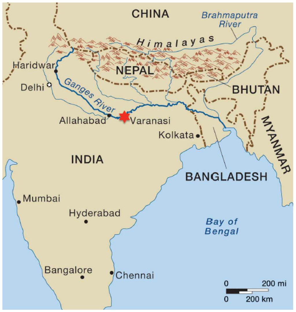
Ganges River basin
from https://www.nationalgeographic.org/encyclopedia/ganges-river-basin/
The Ganges (Ganga) River runs through northern India and is sacred to those who follow Hinduism. More than four hundred million people in India live in the area that feeds the river, known as the Ganges River Basin. A river basin is a region that is drained by a river, such as the Ganges, and any of its tributaries. This means that surface water and rainwater in the basin area flow into the nearby rivers.
The melting water from the Himalayas, as well as water from tributaries and rainfall, all feed the sacred river. The Ganges flows south and east from the Himalayas, forming a canyon as it leaves the mountain. It winds its way through northern India, eventually emptying into the Bay of Bengal. The Ganges’ many tributaries originate from the nearby countries of Nepal, Bangladesh, and China (in an autonomous region called Tibet).
The Ganges River carries nutrient rich sediment as it flows, depositing fertile soil along its shores. This has allowed civilizations to develop and thrive along the waterway for centuries. Today, the river flows through well-populated regions of India, providing freshwater to the millions of people living in these regions. The river is also used for fishing, irrigation, and bathing, and it is worshiped in the Hindu religion as the Mother Ganga. As the river empties into the Bay of Bengal, the mouth forms the Ganges River Delta, the largest river delta in the world.
The Ganges River is a vital resource to Asia, but it faces many threats. Human and industrial pollutants fill the river in some areas, making it unsafe even for swimming. As the population in regions surrounding the river swells, water demands for agriculture increases, straining water levels. Adding further stress to the situation, scientists have concluded that climate change has led to a decrease in glacial ice in the Himalayas, the source of the Ganges, and theorize this will result in further decreased water levels in the river over time.
How many people live along the Ganges River basin? ___(17)___
To which religious faith is the Ganges consider to be a sacred river? ___(18)___
In which country is Tibet located? ___(19)___
Besides rainfall and small river (called tributaries) what is the source of the Ganges water? ___(20)___
To which religious faith is the Ganges consider to be a sacred river? ___(18)___
In which country is Tibet located? ___(19)___
Besides rainfall and small river (called tributaries) what is the source of the Ganges water? ___(20)___
|
|
|
Assignment for March 25th-26th; March 29th-30th
This is the makeup for the India Exam
the answers will be different than the original assignment

Chhatrapati Shivaji Terminus (railroad station) in Mumbai was known as Victoria Station during the British rule of India. Mumbai was once known as Bombay.
|

Kandariya Mahadeva Temple in Central India was built in the 11th century. The temple is dedicated to the Hindu god, Shiva.
|

from https://www.enchantedlearning.com/asia/india/flag/#:~:text=The%20Flag%20of%20India&text=The%20Indian%20flag%20has%20three,dark%20blue%20half%2Dmoon).
India's flag was adopted on July 22, 1947, after India became independent from Great Britain. The flag was based upon the design of the flag of the Indian National Congress. The Indian flag has three equal horizontal bars (saffron, white and green) with a blue Dharma Chakra (the wheel of law) in the center. The wheel has 24 spokes, representing the 24 hours in a day (at the end of each spoke is a dark blue half-moon). The orange (deep saffron) symbolizes courage and sacrifice (saffron is the sacred color of Hinduism). The white stands for peace, unity and truth. The green stands for fertility (although it originally symbolized Islam). The blue symbolizes the sky and the ocean. The height of this flag is two-thirds the width. |
The Bengal Tiger is native to the Indian subcontinent. In Walt Disney's 1967 adaption of Rudyard Kipling's book, The Jungle Book, a tiger named Shere Khan is the villain. The name "Khan" refers to a person of nobliity.
|

political map of India
|
https://kids.nationalgeographic.com/geography/countries/article/india#:~:text=India%20is%20part%20of%20the,bordered%20by%20the%20Arabian%20Sea.
Geography of India India is part of the continent of Asia. Most of India forms a peninsula, which means it is surrounded by water on three sides. The world's highest mountain range, the Himalaya, rises in the north. The southeast is bordered by the Bay of Bengal, and the southwest is bordered by the Arabian Sea. India's terrain varies widely, from the Thar Desert in the west to jungles in the northeast. A fertile area called the Ganges Plain covers much of northern India. This formation was created from soil that was deposited by rivers running from the Himalaya. |
|
|
|
Monsoon rains
from https://www.experiencetravelgroup.com/blog/2020/08/monsoon-season-india/
There are two monsoons (or rainy seasons) in India. The summer monsoon season in India, otherwise known as the
southwest monsoon, which lasts from June to September and affects the whole of India. Then the northeast or winter
monsoon brings seasonal rainfall to Southeast India from October to December.
Monsoons are caused by a pressure difference between sea and land, bringing seasonal winds and rains.
The southwest monsoon occurs after the hot summer. The huge landmass of India heats up at a different rate to the
surrounding sea, and the extreme heat of the Thar Desert in Rajasthan (a state in India) draws in moisture-laden winds from the
low-pressure area in the Arabian sea. The winds first hit the Western Ghats of Kerala (a state in India), this land relief
causes the air to rise and cool with subsequent rainfall, they then move northwards. The rains reach Kerala
round the beginning of June, usually arrive in Mumbai approximately 10 days later, then Delhi by the end of June,
and the rest of India by mid-July.
The reverse happens in winter, during the northeast monsoon. The land is colder than the sea, so the pressure
gradient is from land to sea. Winds blow over the Indian subcontinent toward the Indian Ocean in a northeasterly
direction, passing over the Bay of Bengal picking up moisture, and causing rain in Tamil Nadu
(a state in India) in October – November.
|
|

map of the states of India
|
|
from https://www.history.com/topics/religion/hinduism#:~:text=Hinduism%20is%20the%20world's%20oldest,world's%20Hindus%20live%20in%20India.
Hinduism is the world’s oldest religion, according to many scholars, with roots and customs dating back more than 4,000 years. Today, with about 900 million followers, Hinduism is the third-largest religion behind Christianity and Islam. Roughly 95 percent of the world’s Hindus live in India. Because the religion has no specific founder, it’s difficult to trace its origins and history. Hinduism is unique in that it’s not a single religion but a compilation of many traditions and philosophies. |
|
Complete the India Exam
answer the questions on a separate piece of paper before completing the assignment on Schoology
answer the questions on a separate piece of paper before completing the assignment on Schoology
In which year did India become an independent country? ___(1)___
Which European country governed India just prior to its independence? ___(2)___
On the Indian national flag, with which religion is the saffron color is associated? ___(3)___
Look at the political map of India. Which city is the capital of India? ___(4)___
India is bordered by the Bay of Bengal, the Laccadive Sea and the ___(5)___ Sea.
During which months does the southwest monsoon bring rain to India? ___(6)___
Use the CIA world factbook to answer questions 7-11
India is rich in natural resources. India has the world's 4th largest amount of ___(7)___
In 2017, India exported $304 Billion worth of goods. To which country was $15.6 Billion of those exported? ___(8)___
What language is spoken by over 40% of people living in India? ___(9)___
Most people in India practice Hinduism. What is the second most widely practiced religion? ___(10)___
What percent of Indians are able to read and write? ___(11)___
Use the Human Development Index to answer questions 12-14
What is India's rank in the Human Development Index? ___(12)___
For how many years does an average citizen of India live? ___(13)___
Look under the health tab. In the United States the infant mortality rate is 5.6 (per 1,000 live births).
In India the mortality rate for infants (per 1,000 live birth) is ___(14)__.
Read the CNN article about Sikhism to answers questions 15-17
In Sikhism, what is a gurdwara? ___(15)___
Sikhism is the world's fifth most practiced religion. How many millions of people practice Sikhism? ___(16)___
What is unusual about the way Sikh men groom their hair? ___(17)___
Read the article about Indian Cobras to answer questions 18-20
The article notes that Indian cobras are members of "the big four" species of snakes.
To what does thephrase "big four" refer? ___(18)___
The articles notes that cobras are diurnal. What does diurnal mean? (You might have to look the term up) ___(19)___
The articles notes that cobras are precocial. What does precocial mean? (You might have to look the term up) ___(20)___
assignment for 3/25 or 3/26
Cities of the Southeast Asia
(1) click the button for your class and see which city you will research
(2) after you have finished; email the page to [email protected]
this is due before the next progress report is issued
Cities of the Southeast Asia
(1) click the button for your class and see which city you will research
(2) after you have finished; email the page to [email protected]
this is due before the next progress report is issued
assignment for March 31st and April 1st
this is the makeup for Pakistan Afghanistan quiz which
will open on Wednesday, April 21
Pakistan and Afghanistan

Islamabad is the capital city of Pakistan
|

Over 95% of Pakistanis practice Islam
|

The Indus River flows through Pakistan
|
from https://www.thoughtco.com/geography-of-pakistan-1435275
General Facts
Pakistan, officially called the Islamic Republic of Pakistan, is located in the Middle East near the Arabian Sea and the
Gulf of Oman. It is bordered by Afghanistan, Iran, India, and China. Pakistan is also very close to Tajikistan, but the
two countries are separated by the Wakhan Corridor in Afghanistan. The country has the sixth-largest population in the
world and the second-largest Muslim population in the world after Indonesia.
Geography and Climate
Pakistan has a varied topography that consists of the flat, Indus plain in the east and the Balochistan plateau in the west.
In addition, the Karakoram Range, one of the world's highest mountain ranges, is in the north and northwest part of the
country. The world's second-highest mountain, K2, is also within Pakistan's borders, as is the famous 38-mile (62 km)
Baltoro Glacier. This glacier is considered one of the longest glaciers outside of the Earth's polar regions.
The climate of Pakistan varies with its topography, but most of it consists of hot, dry desert, while the northwest is
temperate*. In the mountainous north, though, the climate is harsh and considered Arctic.
Economics and Land Use
Pakistan is considered a developing nation and has a highly underdeveloped economy. This is largely because of its
decades of political instability and a lack of foreign investment. Textiles** are Pakistan's main export, but it also has
industries that include food processing, pharmaceuticals***, construction materials, paper products, fertilizer, and shrimp.
Agriculture in Pakistan includes cotton, wheat, rice, sugarcane, fruits, vegetables, milk, beef, mutton****, and eggs. Resources include
natural gas reserves and limited petroleum.
* temperate means it's not too hot or too cold
** textiles is the production of cloth
*** pharmaceuticals means the manufacture medicine
**** mutton is the meat of older sheep.

Pakistan Export Tree
Pakistan takes the game of cricket very seriously, and it doesn't get any more serious as when Pakistan plays India
|
Food tour in Lahore, Pakistan. Pakistan is a Muslim country--you will not see very many pork products
The Kashmir Valley is claimed by both Pakistan and India
|

Kabul is the capital of Afghanistan and the site of terrorist attacks against the government and the United States
|

the flag of Afghanistan
|

Afghanistan is landlocked
|
from https://www.thoughtco.com/geography-of-afghanistan-1434322
General Facts
Afghanistan, officially called the Islamic Republic of Afghanistan, is a large, landlocked country located in Central Asia.
About two-thirds of its land is rugged and mountainous, and much of the country is sparsely* populated. Afghanistan's
people are very poor and the country has recently been working to achieve political and economic stability despite the
reemergence of the Taliban**, following its fall in 2001.
Geography and Climate
Two-thirds of Afghanistan's terrain consists of rugged mountains. It also has plains and valleys in the northern
and southwestern regions. The valleys of Afghanistan are its most populated areas and much of the country's
agriculture takes place either here or on the high plains. Afghanistan's climate is arid*** to semiarid and has very
hot summers and very cold winters.
Economics and Land Use
Afghanistan's economy is currently recovering from years of instability but it is considered one of the poorest
nations in the world. Most of the economy is based on agriculture and industry. Afghanistan's top agricultural products are
opium****, wheat, fruits, nuts, wool, mutton, sheepskins, and lambskins; its industrial products include textiles,
fertilizer, natural gas, coal, and copper.
* sparsely populated means there are not many people living there
**the Taliban are Islamic extremists who DO NOT like the United States
***arid means dry
****opium is made from poppy flowers. It is used to make illegal drugs like heroin

Afghanistan export tree
|
The Afghanistan conflict has been the longest war in the
history of the United States |
Who Are the Taliban?
from https://www.bbc.com/news/world-south-asia-11451718
The Taliban, or "students" in the Pashto* language, emerged in the early 1990s in northern Pakistan following the withdrawal
of Soviet troops from Afghanistan.
It is believed that the predominantly Pashtun movement first appeared in religious seminaries - mostly paid for by money
from Saudi Arabia - which preached a hardline form of Sunni Islam.
The promise made by the Taliban - in Pashtun areas straddling Pakistan and Afghanistan - was to restore peace and security
and enforce their own austere version of Sharia, or Islamic law, once in power.
From south-western Afghanistan, the Taliban quickly extended their influence.
In September 1995 they captured the province of Herat, bordering Iran.
Exactly one year later, they captured the Afghan capital, Kabul, overthrowing the regime of President Burhanuddin Rabbani -
one of the founding fathers of the Afghan mujahideen**.
By 1998, the Taliban were in control of almost 90% of Afghanistan.
Afghans, weary of the mujahideen's excesses and infighting after the Soviets were driven out, generally welcomed the
Taliban when they first appeared on the scene.
Their early popularity was largely due to their success in stamping out corruption, curbing lawlessness and making the
roads and the areas under their control safe for commerce to flourish.
But the Taliban also introduced or supported Islamic punishments - such as public executions of convicted murderers
and adulterers, and amputations for those found guilty of theft.
Men were required to grow beards and women had to wear the all-covering burka***.
The Taliban banned television, music and cinema, and disapproved of girls aged 10 and over going to school.
They were accused of various human rights and cultural abuses. One notorious example was in 2001, when the
Taliban went ahead with the destruction of the famous Bamiyan Buddha statues**** in central Afghanistan, despite international outrage.
The attention of the world was drawn to the Taliban in Afghanistan following the attacks on the World Trade Center
in September 2001.
The Taliban were accused of providing a sanctuary to Osama Bin Laden and the al-Qaeda movement who were blamed
for the attacks.
On October 7, 2001, a US-led military coalition invaded Afghanistan and by the first week of December the Taliban regime had collapsed.
*Pashto language is the national language of Afghanistan and spoken by about 15% of Pakistanis
**mujahideen is the name for the Afghani fighters who opposed the Soviet (Russian) invasion army
***burka (see the picture below)
****Bamiyan Buddha statues (see the picture below)
|

the Bamiyan Buddhas were destroyed by the Taliban
|

The Indus River Civilization
from https://courses.lumenlearning.com/boundless-worldhistory/chapter/the-indus-river-valley-civilization
The Indus Valley Civilization (also known as the Harappan Civilization) was a
Bronze Age society extending from modern northeast Afghanistan to Pakistan and northwest India.
The Indus Valley Civilization existed through its early years of 3300-1300 BCE, and its mature period of 2600-1900 BCE.
The area of this civilization extended along the Indus River from what today is northeast Afghanistan, into Pakistan
and northwest India. The Indus Civilization was the most widespread of the three early civilizations of the ancient world,
along with Ancient Egypt and Mesopotamia. Harappa and Mohenjo-daro were thought to be the two great cities of
the Indus Valley Civilization, emerging around 2600 BCE along the Indus River Valley in the Sindh and Punjab
provinces of Pakistan. Their discovery and excavation in the 19th and 20th centuries provided important
archaeological data about ancient cultures.
The Indus Valley Civilization was one of the three “Ancient East” societies that are considered to be the cradles of
civilization of the old world of man, and are among the most widespread; the other two “Ancient East” societies are
Mesopotamia and Pharonic Egypt.
At its peak, the Indus Valley Civilization may had a population of over five million people. It is considered a
Bronze Age society, and inhabitants of the ancient Indus River Valley developed new techniques in metallurgy—the science
of working with copper, bronze, lead, and tin. They also performed intricate handicraft, especially using products
made of the semi-precious gemstone Carnelian, as well as seal carving— the cutting
of patterns into the bottom face of a seal used for stamping. The Indus cities are noted for their urban planning,
baked brick houses, elaborate drainage systems, water supply systems, and clusters of large, non-residential buildings.

Indus River Valley civilization map
|

"First Four" Ancient Civilizations
|
Carnelian bracelet
|
Makeup for the Pakistan-Afghanistan quiz
write the answers on a piece of paper before completing the assignment on Schoology
write the answers on a piece of paper before completing the assignment on Schoology
Which city is the capital of Pakistan? ___(1)___
The Indus River begins in the Himalayas and flows through Pakistan.
Into which body of water does it empty? ___(2)__
What is the official name of the country of Pakistan? ___(3)___
Pakistan has a large population for its size. Where does Pakistan rank among the world's population?___(4)___
What is K2? ___(5)___
What type of climate is found in most of Pakistan?___(6)___
The leading industry in Pakistan is textile production. What are textiles? ___(7)___
Cotton is the most important cash crop grown in Pakistan. What edible crop accounts for
10% of Pakistan's exports? ___(8)___
click the button that says, "CIA World factbook: Pakistan"
Who are the largest ethnic group in Pakistan?___(9)__
What is the official language spoken in Pakistan? ___(10)___
Which city is the capital of Afghanistan? ___(11)___
Like Pakistan, Afghanistan produces a lot of mutton. What is mutton? ___(12)___
Which non-edible cash crop accounts for 11% of Afghanistan's exports? ___(13)___
The Taliban required burkas. What is a burka? ___(14)___
click the button that says, "CIA world factbook: Afghanistan
What language do 77% of the Afghan population speak? ___(15)___
Harrapa and Mohenjo-daro were ___(16)___
The cities of the Indus River made their houses from ___(17)___
This is the (4/28) makeup for
Nepal and Bhutan
the answers to the makeup will be different from the original assignment
the quiz questions are at the end of the section

Bhutanese style architecture at UTEP
|

Both Nepal and Bhutan are located in the mountains of South Asia
|

Kathmandu is the capital of Nepal
1.44 M (2020) 80% of Nepalese practice Hinduism |

Much of Nepal is located at high elevations making farming
and the transportation of goods difficult |
Nepal
from https://www.nationsonline.org/oneworld/nepal.htm
Nepal [is a] landlocked, multiethnic, multilingual, multi-religious country situated north of India in the Himalayas,
in the region where, about 40 to 50 million years ago, the Indian subcontinent has crashed into Asia. Because of that
accident, Nepal has some of the world's highest mountains including Sagarmatha (Mt. Everest). . .
Somewhere in the Kapilavastu district, there is a place called Lumbini where in about 500 B.C.E.
Queen Mayadevi is said to have given birth to Siddhartha Gautama, better known as Buddha.
Nepal can be divided broadly into three ecological zones: the lowland, the midland and the highland.
The altitude of the Himalayan Region (the highland) ranges between 4877 m - 8848 m.
It includes 8 of the highest 14 summits in the world, which exceed altitude of 8000 meters including Mount Everest.
The mountain region (the midland) accounts for about 64 percent of total land area, which is formed by
the Mahabharat range that soars up to 4877 m and the lower Churia range.
The lowland Terai, the flat river plain of the Ganges with a belt of marshy grasslands,
savannas, and forests, occupies about 17 percent of the total land area of the country.
|
|
|

The Import/Export List for Nepal
Rs= Nepalese Rupee |

Nepal Export Tree
|
|
from https://www.196flavors.com/nepal-dal-bhat/
Dal bhat is the ultimate vegetarian Nepalese dish. This is the basic meal for the country, Nepali cuisine at its best, consisting of rice and lentils. Nepalese dal bhat (dal bat or dhal bhat) is composed of white rice (bhat) and lentils (dal) and it is typically accompanied by a vegetable curry (tarkari), a mixture of spicy vegetables (pickles) and greens (sak). It is eaten with papadums in a large metal tray. |

A plate of dal bhat
|

Nepal farmers grow a lot of legumes
and pulses |
Bhutan
from https://www.goway.com/travel-information/asia/bhutan/geography-and-maps/#:~:text=Bhutan%20is%20a%20small%2C%20landlocked,Himalayans%20and%20the%20Southern%20Foothills.
Bhutan is a small, landlocked country located in southern Asia between Tibet and India. The topography of the country
can be divided into different regions from north to south based on altitude: the Great Himalaya, the Inner Himalayans
and the Southern Foothills.
The Great Himalayas are a mountain range that stretches from Mt. Chomolhari (7,314m) in the west to Kulha Gangri (7,554m)
near the center of the northern border between Tibet and Bhutan. Due to the elevation of the highest summits,
20% of the area is covered perpetually by snow. The rest of the region is characterized by alpine meadows.
The Inner Himalayans are the largest geographical region in Bhutan. They are characterized by broad valleys and
forested hillsides and the majority of major towns in Bhutan including Paro, Thimpu and Punakha are located here.
The Southern Foothills (also known as the Himalayan Foothills) are located in the southern part of the country.
The average rainfall here is quite high reaching up to 200 inches. As a result of this rain, the Southern Foothills are
known for lush vegetation and tropical forests. These forests are full of diverse wildlife and days here can get very hot.
Rivers are also very important to Bhutan’s geography because they are a source of hydroelectric power.
Due to the monsoon season that the country experiences, rivers and valleys here are wider than in Nepal and India.

Thimpu is the capital city of Bhutan
|
|
|
|

Export Tree for Bhutan
|
complete the Nepal-Bhutan quiz
write the answers on a piece of paper before completing the assignment on Schoology
write the answers on a piece of paper before completing the assignment on Schoology
Which city is the capital of Nepal? ___(1)___
By what other name is Siddhartha Gautama known? ___(2)___
There are 3 ecological zones in Nepal. which one is part of the Ganges flood plain? ___(3)___
Look on the CIA World Fact book page : Nepal to answer questions 4-6
Nepal's four most important natural resources are: quartz, water, timber and ___(4)___
16.6% of the people living in Nepal belong to the ___(5)___ ethnic group
What is the official language spoken in Nepal? ___(6)___
What product(s) are Nepal's top import?___(7)___
What (product(s) are Nepal's top export? ___(8)___
Look at the Nepal export Tree to answer this question
What metal product accounts for 8.2% of Nepal's exports? ___(9)___
Click the currency exchange converter button to answer these two questions
$10.00 US = ___(10)___ NPR (Nepalese Rupees)
$10.00 US= ___(11) ___ BTN (Bhutanese Ngultrums)
What are the "bhat" on a plate of dal bhat? ___(12)___
Why are Bhutan's rivers very important to the economy of Bhutan? ___(13)___
What city is the capital of Bhutan? ___(14)___
Look on the CIA World Fact book page : Nepal to answer questions 15-16
Bhutan's four most important natural resources are: ___(15)___, hydropower, gypsum and calcium carbonate*
Which religion is the most widely practiced in Bhutan? ___(16)___
* calcium carbonate is used to make cement
This is the makeup for
Bangladesh
some of the questions have changed from the original assignment

from https://worldpopulationreview.com/world-cities/dhaka-population
Dhaka is the capital and largest city in Bangladesh Dhaka's 2021 population is now estimated at 21,741,090. In 1950, the population of Dhaka was 335,760. Dhaka has grown by 735,230 since 2015, which represents a 3.50% annual change. . . It is one of the most densely populated areas in the world, with a density of 23,234 people per square kilometer within a total area of 300 square kilometers. |

from https://www.infoplease.com/world/countries/bangladesh
Bangladesh, on the northern coast of the Bay of Bengal, is surrounded by India, with a small common border with Myanmar in the southeast. The country is low-lying riverine land traversed by the many branches and tributaries of the Ganges and Brahmaputra rivers. Tropical monsoons and frequent floods and cyclones inflict heavy damage in the delta region. |

Bangladesh has a very large population
|
from https://www.nationsonline.org/oneworld/bangladesh.htm
The country is situated in the fertile plains of the Ganges (Padma) River delta and borders the Bay of Bengal.
Bangladesh borders various states of India in the west, north and east and has a short border with Myanmar (Burma)
in the southeast. Bangladesh is one of the most densely populated countries in the world with an estimated 171 million people
(in 2021). The majority of its population are followers of Islam (nearly 90%). The capital and largest city is Dhaka. Spoken
language is Bangla (or Bengali by 98%).

Bangladesh Export Tree
|
|


Sixty Dome Mosque was completed in 1459
|
video on street food in Dhaka
|

Hilsa fish curry

aloo (potato) palak (spinach) paratha (bread) is
bread w/spinach & potato stuffing |
from https://travelfoodatlas.com/traditional-foods-bangladesh-top-9-must-try-bangladeshi-dishes#:~:text=Hilsa%20(or%20ilish)%20curry%20is,most%20popular%20traditional%20Bangladeshi%20dishes.
Hilsa (or ilish) curry is the national dish of Bangladesh, made from the Hilsa fish, and is one of the most popular traditional Bangladeshi dishes. The Hilsa fish is marinated in turmeric and chili paste, before slowly frying on a low heat and serving with a mustard gravy and rice. The result is a combination of sweet and sour flavours with an incredible spicy kick. Aside from being cheap, Hilsa curry is filling, flavoursome, easy to make and widely available due to the amount of Hilsa fish in the region, especially during rainy season. The sheer abundance of the Hilsa fish is why Hilsa Curry is the national dish of Bangladesh. In Bangladesh it is common to eat every part of the Hilsa fish including the head and the eggs, nothing is wasted and each part even has its own unique delicacies. |
This is the makeup for
Bangladesh
some of the questions have changed from the original assignment
answer the questions on a separate piece of paper before completing the assignment on Schoology
Bangladesh
some of the questions have changed from the original assignment
answer the questions on a separate piece of paper before completing the assignment on Schoology
In 2021 what is the estimated population for the capital city of Bangladesh? ___(1)___
Bangladesh shares a borders with the countries of Myanmar and ___(2)___
Look at the (2015) bar graph titled, "10 Most Populated Countries in the World"
In 2015 the United States was the 3rd most populated country. What rank was Bangladesh? ___(3)___
Complete this list of the four most populated countries: China, India, ___(4)__ and Indonesia
click the button titled "Bangladesh Population"-it should take you to this website:
https://www.worldometers.info/world-population/bangladesh-population/
What is the population of Bangladesh today? ___(5)___
Scroll down to Bangladesh Demographics
What is the average life expectancy in Bangladesh? ___(6)___
click the button titled, "Bangladesh Population Pyramid" -it should take you to this website:
https://www.populationpyramid.net/bangladesh/2019/
According to the population pyramid, males age 55-59 make up 2.0% of the population of Bangladesh.
Which group is the largest with 4.9% of the population? ___(7)__
click the button titled, "CIA World Factbook: Bangladesh-it should take you to this website:
https://www.cia.gov/the-world-factbook/static/f0fc26297bcce53db130339eca2ed175/BG-summary.pdf
Look under Natural Resources
Bangladesh's natural resources are: natural gas, arable land, timber and ___(8)___.
Look under People & Society
At least 98% of the population of Bangladesh are ____(9)___ making them the largest ethnic group in that country.
Over 89% of the population of Bangladesh are ___(10) making them the largest religion in that country.
Look at the Bangladesh Export Tree
What clothing item is Bangladesh largest export? ___(11)___
click the button titled, "Bhola Cyclone (1970)"-it should take you to this website:
https://weather.com/storms/hurricane/news/2019-05-01-deadliest-tropical-cyclone-bhola-cyclone-bay-of-bengal-bangladesh
In which month did the Great Bhola Cyclone occur? ___(12)___
What was the estimated number of death due to the cyclone? ___(13)___
Bangladesh has had a tragic history of due to cyclones because the land is flat and low-lying.
Also, Bangladesh is located next to a large body of water that produces cyclones.
What body of water borders Bangladesh? ___(14)___
What is the "aloo" on a plate of aloo palak paratha? ___(15)___
assignment for Thursday 15th April or Friday 16th
Sri Lanka and the Maldives
the quiz questions are at the end of the section

Sri Lanka is an island off the east coast of India. The capital city is Colombo. in 2020, the estimated population for Colombo and the surrounding towns was 5.6 Million
|
|

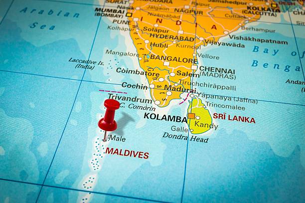
the Maldives form an archipelago* off the west coast of India. The capital city is Male
*an archipelago is a group of islands
|
Democratic Socialist Republic of Sri Lanka

from https://flagpedia.net/sri-lanka
The "Lion Flag" of Sri Lanka was adopted in 1948, but it was used as a symbol of justice for a long time before. Its main motive is yellow lion on a red field holding a sword as a symbol of power. Green and red stripes were added to the left part of the flag after 1815 and these stripes are intended to symbolize Hindu Tamils and Muslim Maurs minorities living on the island beside the Sinhalese majority. Moreover, after renaming in 1972 from Ceylon to Sri Lanka, four yellow leaves were added to the lion´s field. Each leaf should remind one of the Buddhist values - kindness, compassion and desire to be a benefit for the society, joy, peace and well-balanced mind. |
Geography and Climate of Sri Lanka
from https://www.thoughtco.com/geography-of-sri-lanka-1435578 Overall, Sir Lanka has a varied terrain but it mainly consists of flatlands. The south-central portion of the country's interior features mountain and steep-sided river canyons. The flatter regions are the areas where most of Sri Lanka's agriculture takes place, aside from coconut farms along the coast. Sri Lanka's climate is tropical and the southwestern part of the island is the wettest. Most of the rain in the southwest falls from April to June and October to November. The northeastern part of Sri Lanka is drier and most of its rain falls from December to February. Sri Lanka's average yearly temperature is around 86 degrees to 91 degrees (28°C to 31°C). An important geographic note about Sri Lanka is its position in the Indian Ocean, which made it vulnerable to one of the world's largest natural disasters. On December 26, 2004, it was struck by a large tsunami that hit 12 Asian countries. Around 38,000 people in Sri Lanka were killed during this event and much of Sri Lanka's coast was destroyed. |
|

Sri Lanka's tropical beaches
|

Sri Lanka's Economy
from https://www.thoughtco.com/geography-of-sri-lanka-1435578
Sri Lanka's economy today is mainly based on the service and industrial sector; however, agriculture plays an
important role as well. The major industries in Sri Lanka include rubber processing, telecommunications, textiles,
cement, petroleum refining, and the processing of agricultural products. Sri Lanka's main agricultural exports include rice,
sugarcane, tea, spices, grain, coconuts, beef, and fish. Tourism and the related services industries are also growing in Sri Lanka.

A street in Colombo
|

Sri Lanka export tree
|
The Republic of the Maldives
from https://www.travelonline.com/maldives/geography
Sitting in the Indian Ocean, south-west of India, the Maldives has a total land mass of 298 sq km, making it the smallest Asian country. While the Maldives boasts an expansive underwater mountain range, only 1% of the country actually breaks the water’s surface.
The Maldives is made up of 26 coral atolls and has approximately 1,190 islands which span over 90,000 sq km of ocean. Most atolls are fringed by large ring-shaped coral reefs which support the islands. Only 200 of the Maldives’ islands are inhabited full time and approximately 100 are occupied by hotels and resorts.
The Maldives is an incredibly low-lying region located 717 km from Sri Lanka and 430 km from India. While a few islands feature sand dunes, generally, the land rises between 1 and 1.5 metres above sea level, making it one of the most unique landscapes on earth. Consisting mainly of vibrant coral reefs and pristine sand bars, the Maldives is home to over 2,000 species of fish. Additionally, with its breathtaking backdrops and brilliant blue waters, the Maldives offers plenty of opportunities for beach going, snorkeling and scuba diving.
Many visitors begin their Maldives holiday upon arrival in Malé. The main island, Malé is the capital and most populous city with approximately 133,000 residents. With an area of just 9.27 sq km, Malé is considered one of the most densely populated cities in the world. The city is also home to the government quarters, a hospital and schools. While you can stay on the island, most visitors will only visit Malé for the international airport. Speedboats and scenic flights are available to transport guests from Malé to their resorts.
The Maldive Islands are a series of atolls
|

|

Male is the capital city of the Maldives
|
from https://www.reuters.com/article/us-climate-change-maldives/
we-cant-wait-maldives-desperate-for-funds-as-islands-risk-going-under-idUSKBN1ZG0XS
'We can't wait': Maldives desperate for funds as islands risk going under
January 2020/ Alasdair Pal, Devjyot Ghoshal
NEW DELHI (Reuters) - The tropical Maldives may lose entire islands unless it can quickly access cheap financing to
fight the impact of climate change, its foreign minister said.
The archipelago’s former president Mohamed Nasheed famously held a cabinet meeting underwater to
draw attention to submerging land and global warming a decade ago.
Yet the Maldives, best known for its white sands and palm-fringed atolls that draw luxury holiday-makers,
has struggled to find money to build critical infrastructure like sea-walls.
“For small states, it is not easy,” Foreign Minister Abdulla Shahid told Reuters in New Delhi. “By the time the
financing is obtained, we may be underwater.”
One of the world’s lowest-lying countries, more than 80% of the Maldives’ land is less than one meter
above mean sea levels, making its population of around 530,000 people extremely vulnerable to storm surges,
sea swells and severe weather.
In 2004, the Indian Ocean tsunami ravaged the Muslim-majority state, causing financial losses of around
$470 million - 62% of GDP - and hitting infrastructure, including its only international airport that was shut for several days.

a sea wall protects the city of Male
|

Maldives export tree
|
|
|
|
This is the makeup for
Sri Lanka & the Maldives
some of the questions have changed from the original assignment
answer the questions on a separate piece of paper before completing the assignment on Schoology
Sri Lanka & the Maldives
some of the questions have changed from the original assignment
answer the questions on a separate piece of paper before completing the assignment on Schoology
In 2020 what was the estimated population of the the capital city of Sri Lanka? ___(1)___
What is an archipelago? ___(2)___
The four leaves on the flag of Sri Lanka are supposed to remind people of ___(3)___
What was the country of Sri Lanka called before 1972? ___(4)___
Overall, Sir Lanka has a varied terrain, but it mainly consists of ___(5)___
Sri Lanka's climate is ___(6)___ with the southwestern part of the island the wettest.
Look at the Sri Lanka export tree
What agricultural product accounts for 14% of Sri Lanka's exports? ___(7)___
click the button titled, "Sri Lanka Population"
What is the current population of Sri Lanka (in 3 digits) ___(8)___
Scroll down to Sri Lanka Demographics
What is the life expectancy for a resident of Sri Lanka? ___(9)__
click the button titled, "Sri Lanka Pop. Pyramid"
Which age group and gender is the largest in Sri Lanka? ___(10)___
click the button titled, "CIA World Fat Book: Sri Lanka"
the largest ethnic group in Sri Lanka is ___(11)__
the official language of Sri Lanka is ___(12)___
Most of the Maldives is an underwater mountain range. What percent of the Maldives is
actually above the surface of the sea? ___(13)___
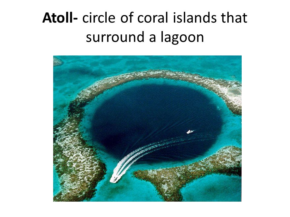
What is an atoll? ___(14)___
What city is the capital of the Maldives? ___(15)___
The Maldives is one of the world's lowest-lying countries, more than ___(16)___ of the Maldives
is less than one meter* above the sea level.
Look at the Maldives export tree
What product accounts for 37% of the Maldives' exports? ___(17)___
click the button titled currency converter
$10.00 USD (US dollars)= ___(18)___ MVR (Maldivian Rufiyaa) the answer should be in 3 digits
click the button titled, "CIA World Fact Book: Maldives"
What is the official language spoken in the Maldives? ___(19)___
What is the official religion practiced on the Maldives? ___(20)___
*a meter is 39 inches
What is an archipelago? ___(2)___
The four leaves on the flag of Sri Lanka are supposed to remind people of ___(3)___
What was the country of Sri Lanka called before 1972? ___(4)___
Overall, Sir Lanka has a varied terrain, but it mainly consists of ___(5)___
Sri Lanka's climate is ___(6)___ with the southwestern part of the island the wettest.
Look at the Sri Lanka export tree
What agricultural product accounts for 14% of Sri Lanka's exports? ___(7)___
click the button titled, "Sri Lanka Population"
What is the current population of Sri Lanka (in 3 digits) ___(8)___
Scroll down to Sri Lanka Demographics
What is the life expectancy for a resident of Sri Lanka? ___(9)__
click the button titled, "Sri Lanka Pop. Pyramid"
Which age group and gender is the largest in Sri Lanka? ___(10)___
click the button titled, "CIA World Fat Book: Sri Lanka"
the largest ethnic group in Sri Lanka is ___(11)__
the official language of Sri Lanka is ___(12)___
Most of the Maldives is an underwater mountain range. What percent of the Maldives is
actually above the surface of the sea? ___(13)___
What is an atoll? ___(14)___
What city is the capital of the Maldives? ___(15)___
The Maldives is one of the world's lowest-lying countries, more than ___(16)___ of the Maldives
is less than one meter* above the sea level.
Look at the Maldives export tree
What product accounts for 37% of the Maldives' exports? ___(17)___
click the button titled currency converter
$10.00 USD (US dollars)= ___(18)___ MVR (Maldivian Rufiyaa) the answer should be in 3 digits
click the button titled, "CIA World Fact Book: Maldives"
What is the official language spoken in the Maldives? ___(19)___
What is the official religion practiced on the Maldives? ___(20)___
*a meter is 39 inches